Nothing compares to the simple pleasure of a bike ride. J.F.Kennedy
Search this website
Southward Bound
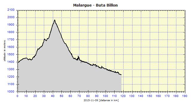
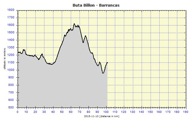
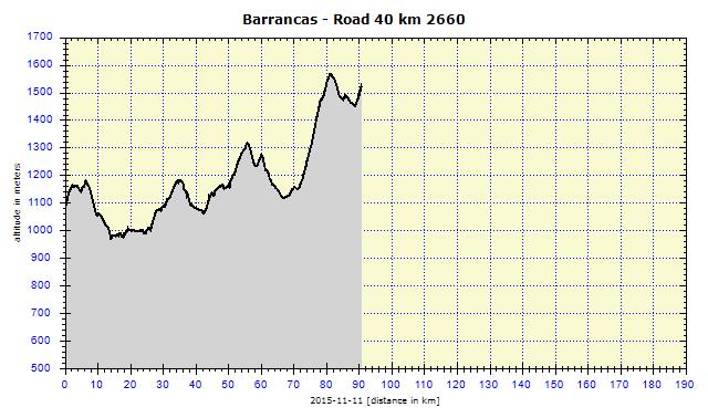
Mendoza, Luján de Cuye, Tupungato, Tunuyán, Paneditas, San Rafael, El Desvio, El Sosneado, Malargue, Bardas Blancas, Ruta Billon, La Pasarela, El Zampal, Laguna Nueva, Barrancas, Buta Ranquil, Aquincó, Chos Malal, Naunauco Pampa, Chorriaca, Bajada del Agrio, Covunco Centro, Zapala
After three days of hanging around, I set out on the road again. My goal was to reach the Lake District. I still did not know how to get there. The main problem of all the available options was the long distances between places selling food. It seemed as if I would need at least a three-day supply. I had 2-3 days to decide, then the road would divide and I would have to choose one of them. I was curious how it would turn out.

Godoy Cruz: Cycle trail from Mendoza also leads across a separate bridge
The road was still wet after the previous night's profuse rain, which ended at 07:00. Overcast, black clouds threatened rain at any moment. Together with all of that, a strong headwind was blowing. I exited Mendoza easily. I found a cycle path going in approximately the correct direction and, when it ended after about 10 km, used the GPS to reach the road I needed. I went for minor roads through the vineyard region in the Luján de Cuyo area. Signs pointed at vineyards everywhere, some of them were directly on my route. Of course, I did not stop there for wine tasting, I needed my head to be clear to face the approaching traffic hazards.

Luján de Cuya: Angelo caught up to me on the road; 4 months before he had visited Prague and warmly praised the Czech Republic
A car overtook me and the driver signaled for me to stop. He was an enthusiast and wanted to chat. In addition, he was also a fan of the Czech Republic. He had visited Prague and even Terezín four months before. He was excited about everything there. I gave him my contact card and he said he would send me an e-mail with the contact details of his friend in San Carlos de Bariloche, who could help me out if necessary.
In Luján de Cuyo city, a lot was happening. The police were redirecting traffic, because some of the crossroads were taken over by protesting people. They had poured oil over the roadway and set fire to it. Black, dense smoke penetrated everything. The protesters expresed their opinions quite openly. The police ignored me, so I followed my route. I avoided the fires easily. The protesters waved at me and called out to me. In this manner, I crossed three intersections, daring to take photos only at the first one and only from a distance.

Luján de Cuya: Rioters, motorists could not pass, but I cycled through, warmly greeted
I continued through the city. In the rear-view mirror, I noticed a car which kept behind me and was not planning to overtake me. This continued for 2 more km, when I read in my dirty mirror, the sign: 'Police'. They finally overtook me, indicating that I should stop. They were going to bully me like in Pergamino, I thought. They first asked me where I was from, the flag interested everyone. Then they explained to me that I was in a dangerous area where I could be attacked and, moreover, the protests were ongoing. They suggested I turn left at the next street and in that way, I would reach Road 40, which would again be safe.

Agrelo: Dying avenue of trees along the road; only thin shells remaining of the tree trunks
I thanked them, we shook hands and tapped our shoulders in the local manner. I liked Road 40, it contained a wide side lane but, according to the map, it was a highway where bicycles were forbidden. This was also the reason I cycled on minor roads. I was right, 300 meters later, signs appeared banning bicycles, horse-drawn vehicles and pedestrians. The highway section was about 30 km long and only then would it become a normal road.

Ascent to Tupungato: Vineyard at 1200-m altitude
I returned to my original plan, exited the highway and entered the minor roads. Both map and GPS offered only one possible bypass, more than 50 km long via Tupungato. This required an ascent to 1400 m above sea level, which was not so obvious on the map. I came across a vineyard cycling trail. At the end of it, I was thankful for the unpaved roads which returned me to the correct road. The continual ascent was unique in crossing through the local specialty: vineyards at 1200 meters above sea level. The grapes had a special taste, as well as the wine from them. Finally I crossed the mountain ridge at about 1400 meters above sea level and descended to the "mountain wine center" of Tupungato.
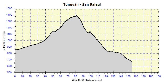
Road 40 then only continued downhill and I could cycle on it at that stage. The wind turned and I had it almost from behind. This is why I wanted to cycle all the way to San Carlos city. The change in the wind, however, also brought about a change in the weather and it started to rain so heavily that I was hard put to seeing the road. I could not help it and had to stay in Tunuyán. I had to stay in Tunuyán. An expensive hotel was located in the main street, I skipped that one. The nearby hospedaje was fully booked. The GPS found another little hotel in a side street, where I finally lay down my head. It was raining so hard that I could not even step outside and was forced to eat most of my supplies. The rain weakened only after about three hours sufficiently for me to go out and purchase some food for the following day.
The following morning, it was still raining. I was not in a hurry and set off after 09:00 on the 160 km to San Rafael. I knew for sure that I would not make it. I was supplied with food and ready to sleep next to the road. Shortly after I started out, the clouds lifted a little and afforded an amazing view over the massive split peaks of the snow-covered Andes. I did not want to take out my camera in the rain, which was a mistake! Five minutes later, the clouds closed in again all the way to the ground and the show was over for the day.

Near San Carlos: Church
The road had a wide paved side lane, quite rough, but cyclable. The road surface was wet, the traffic dense, so I prioritized the safer side lane above the more comfortable cycling in the road itself. It was a good choice. Suddenly I heard a dull bang, pieces of plastic flew around me and, at that moment, a dead dog slid in the road on my left. It had happened several meters behind me and if I had been in the road itself, I would probably have also been injured. The driver overtook me, stopped and complained about his damaged front bumper.

Paneditas: Wrecks outside police station serving as deterrents
The first moment of decision was in Pareditas, where Road 143 separated from Road 40. I decided to continue on Road 40 all the way to Malargüe, 230 km away, and not to cycle through San Rafael. Road 40 was unpaved for the next 120 km. I tried it, but it was terrible. The gravel-sand soaked in water was heavy and soft, the bicycle was sinking in it, a lot of strength was required to pedal. To make sure, I returned to a police station and asked what the road looked like further on. It was to become even worse and I should cycle via San Rafael. I followed their advice.

Paso de las Carretas: Stone church
I purchased some empanadas for dinner, as there would apparently not be anything available on the first 90 km (out of 110) to San Rafael. It was not true. After 10 km, a small restaurant in Paso de las Carretas village was located next to the road. That was, however, the end to it. I was not suffering from a lack of supplies, I was bothered by the never-ending rain. It appeared to stop raining on three occasions, yet as soon as I took off my rainproof pants, it started up again and I had to put them on again.
Then followed an almost two-hour long interval, during which I managed to dry out all the clothes I was wearing. Looking at the clouds, I suspected it was not the end of the rain. The black clouds were closing in over my head, creating an impressive 'black' light. I quickly photographed it at a partly abandoned settlement called La Tosca and once again it started to pour. The rain was very heavy. My shoes were soon soaked and the road flooded. I found a positive side to it, as my bicycle and panniers would be nicely washed.

La Tosca: All three houses in the background form the village of La Tosca, two of which were abandoned

La Tosca: Dry Las Penas riverbed

La Tosca: House

La Tosca: Torso of a bus stop
I certainly was not keen on pitching my tent in the heavy rain. By 17:00 I had cycled 100 km, I had 55 km left to San Rafael, and it would be dusk in about three hours. However, the road was downhill and, even on the flat sections, I kept up a speed of 20 kph, even though I did not have any wind at my back. I put in my best effort and enjoyed it immensely. A pick-up truck driver appeared beside me, adjusted his speed to mine and offered me a lift. I thanked him, but refused, saying that it was not necessary, it was only raining and water surely would not hurt me. He did not seem to believe me and made the offer again. When I refused for the second time, he left, shaking his head. At 20:00, just after sunset, I arrived at San Rafael.
San Rafael
The evening rush had exhausted me and, the following morning, I felt that I needed to rest. I planned to purchase food for the deserted areas ahead of me and to dry out my wet clothes and, most importantly, my water-logged shoes. I did not like the hostel where I found accommodation. Apart from myself, there was also a snooty German. The hostel itself was quite dirty, and the breakfast not worth mentioning. I found one-class better accommodation two blocks away and even saved money, as it was cheaper. They had no problem with guests checking in at 10:00 already.

San Rafael: Unattractive San Rafael Arcángel Cathedral is the most interesting site

San Rafael: Main avenue

San Rafael: Nice homes are in the distinctive minority
It is remarkable that a city can be free of any historical sites and totally lacking in charm. That is the case of San Rafael. The city is relatively large, clean, but apart from one ugly Cathedral and plenty of stores, there is nothing. Only one big supermarket, yet it contained everything I needed. A tourist agency provided me with a Malargüe map and information about the unpaved sections of Road 40, which were quite rough. They said I had quite something ahead of me.

San Rafael: Store for equestrian needs

San Rafael: Little girl and her guardian
Before exiting the city, a big pick-up truck stopped next to me and the driver resolutely announced that he would take me over the next dangerous area. I thanked him warmly, but refused his offer. He refused to take 'no' for an answer and insisted at least on protecting me from other cars. That sounded good, so I agreed. Two long, narrow bridges lay ahead. He drove behind me, warning lights on, and did not allow any car to overtake me on the bridge. Then we warmly bade each other goodbye. Fine guy!

20 km S of San Rafael: Mountain vineyard
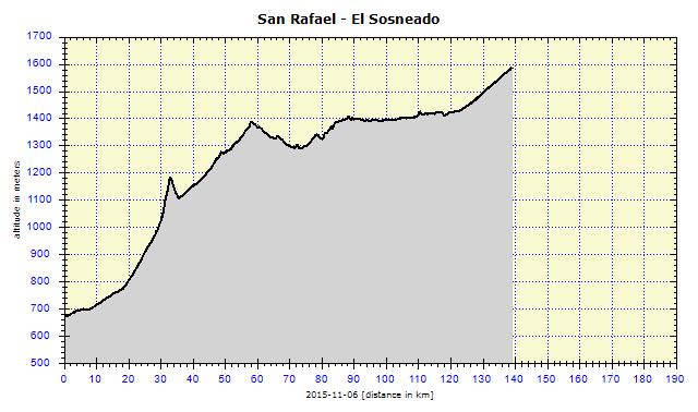
The map showed Road 144 shortly after San Rafael as twisting. Naturally, that meant hills. It was nothing dramatic, I only had to cross the Cuesta Los Terneros highlands. Then the road acted more decently, with only gradual ascents.

Cuesta Los Terneros: Mountain chapel

Cuesta Los Terneros: Guanaca
After 40 km, in El Desvío an isolated building appeared with the sign "parador". There was a very limited selection – three types of sandwiches. I ordered one with ham and cheese and asked for boiling water for my Mate cocido and continued on my way.

15 km N of El Desvio: Advertised services are 50 km away, in El Nihuil, on a road other than this 144

Road 144 km 717: Road signs, shabby due to age
No Laughing Matter – Arrival at the Andes
That was my thought when I looked at the snow-covered Andes peaks on the horizon. It seemed fine, though. The road was not twisting, except the weather started being a bit confused. I had the sun and a slight wind almost from behind all the time. I arrived under a shabby black cloud and it began – strong rain, crazy headwind! I barely forced myself through it. After 10 km, I exited from under the low cloud and relaxation returned, the wind at my back, sunshine.

Near Los Parlamentos: Clouds dramatically changing the weather

Near El Sosneado: Oil pump
I was looking out for camping spots, but the choice was miserable. The road surroundings were narrow, visible, confined by fences and generally with big stones everywhere which would surely be uncomfortable to sleep on. A good option came up at a lay-by, but there were three men present there and I prefer nobody to know about my overnight location.

El Sosneado: I slept in the earthen backyard
After 140 km, quite tired, I arrived in El Sosneado. On the outskirts, there was a kiosk (kiosco) where I bought a can of beer. Surprisingly, I did not like it. Thinking ahead, I asked about a campsite. There were none in the village, but they sent me to a lady who would surely be able to help me. Bingo! She let me sleep in her backyard free of charge (I gave her 40 pesos for it the following morning). The yard had several dogs, four very active pre-school girls, several hens and roosters running around it. All in all, no facilities. Water was available from an adjacent canal and I walked to the edge of the road for a loo.

Near El Sosneado: Andes peaks within reach
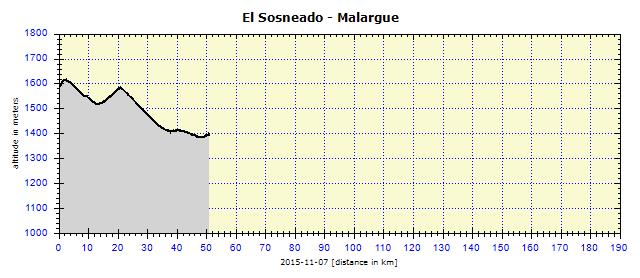
Malargüe was only 50 km away, so I was not in a hurry to leave my warm den and go into cold reality. The roosters woke me up, but I fell asleep again until the girls asking if seňor was still alive reminded me that it was almost 08:00.

Junction to Los Leňas: Río Salado
Beautiful weather, a mild wind at my back, an easy route. I simply enjoyed myself. Las Lenas is a top Argentinian skiing center. It closed on 15th September, otherwise I would have gone there to try it out. The snow is very dry, fluffy powder. Prices in season were exorbitant and intended for the richest people in South America.

Junction to Los Leňas: The arrow points to the biggest and best Argentine ski resort 30 km away
As the weather was so beautiful, I went directly to the city campsite. It was quite busy on a Saturday. Many families were having barbecues there, grilling their carne, before returning home in the evening. It was nice when two families invited me to their table to join their (literal) feast. I excused myself due to my cycling diet, but did not refuse glass of Malbec.

Malargue: Clock at the town entrance

Malargue: Tower indicates the center

Malargue: Like 50 years ago
My tasks were clear: do my laundry, spray the chain and pedals with WD, oil them, tighten the stand and do a general check of the bicycle. Another task was to go on a one-day excursion the following day to the La Payunia Provincial Reserve – an area with the highest density of volcanoes. I looked for local travel agencies. At the first (and only) one – Karen Travel – I reserved a one-day trip to Payunia.
Satisfied with how everything was working out, I went to the Vea supermercado. Two young men there were discussing in Czech whether to buy tomatoes or not. To their surprise, I approved that idea in Czech. From our chat, it came up that they were there to film a show with Dr. Grygar, who was also somewhere in the store and they immediately went to call him.

Malargue: With Dr. Grygar in front of a supermarket
It was a pleasant meeting. Grygar travels there quite often, because there are two stations administered by the Czech Republic in the Malargüe area to observe cosmic radiation. There is a total of more than 2 000 tracking stations in that region. I saw some of them, but did not photograph them. They look like 4x4 meter plastic graves with a stitched solar element. The tub filled with water to trap the space dust is most important. Grygar and I agreed on how great the Czech Republic is and how its citizens are so ungrateful for not appreciating it. People of my age in particular, who have only traveled to tourist destinations, have no idea about the rough life people have in other parts of the world.
Reserva Volcanes de Payunia
I was supposed to be picked up at 08:30 outside the city campsite. They were punctual. I was the 6th and last passenger in the Land Rover. It was puzzling that neither clients, nor driver (and guide) could put together any English words to be able to communicate with me. We had to communicate everything in my miserable Spanish. Finally, we established quite a friendly contact.

Reserva Volcanes de Payunia: Entry to the Reserve is free; the scenic road, passable only by off-road vehicles, begins here

Reserva Volcanes de Payunia: We traveled in a Land Rover
Problems of human communication were not important. The landscape was of importance and it was simply amazing. I was puzzled that it was not classified as a National Park, but only as a Provincial National Reserve. There are more than 800 volcanoes over an area of 4 500 sq. kilometres, apparently the most dense volcanic concentration in the world (I wonder if Kamchatka is included). The Reserve is situated about 200 km from Malargüe and is accessible only by four-wheel drive vehicles. At times, I was surprised at the places our Land Rover managed to get through. Three components are vital – a good quality vehicle, a good driver and terrain knowledge.

Reserva Volcanes de Payunia: Our group, guide in the middle - I am the one in the shirt and pants I've been wearing on my cycling trips every year since 2005 - still preserved

Reserva Volcanes de Payunia: Dark volcanic soil, clumps of grass and volcanoes

Reserva Volcanes de Payunia: Igneous pieces of lava lying on the ground

Reserva Volcanes de Payunia: 3715 m high Payún Matrú

Reserva Volcanes de Payunia: Payún Matrú volcano in the background
Meals were also included in the not so cheap price of the excursion (830 pesos). After the first hour, we received breakfast with coffee, croissants and cake. Shortly after midday, we were given lunch consisting of an unlimited number of ham and cheese sandwiches. Although I announced all the time that, thanks to travelling by bicycle, I was siempre hambre (always hungry), I was not the biggest eater on the trip. I ate three sandwiches, while the husband of the youngest couple ate an unbelievable five. It is important to note that he also had a reasonable beer belly, so had a place to store them. He happily slept for two hours after lunch. But I outsmarted all of them, I took out half a liter of Schneider (beer) from my rucksack and, instead of the offered sweet lemonade, finished lunch like a proper Czech. Meanwhile, I gave them a lecture on Pilsen City in the Czech Republic.

Reserva Volcanes de Payunia: Igneous piece of lava

Reserva Volcanes de Payunia: Black soil contrasting with bright yellow grass

Reserva Volcanes de Payunia: It is interesting that the grass grows on the sharply defined areas for no apparent reason
Our tempo naturally slowed down after lunch. The driver took us to the saddle, where various lava stones were to be seen in various shapes, for example, of prehistoric lizards. Then we had a lunch siesta on a warm lava hill, heated from below by a volcano to an acceptable 38 degrees. We enjoyed the warmth for half an hour and then were taken to the crater.

Reserva Volcanes de Payunia: Statue of lizard made of lava stones

Reserva Volcanes de Payunia: Siesta at noon, we bask on heated lava slag

Reserva Volcanes de Payunia: Some colors are unreal, like here, pitch black blended with dark red

Reserva Volcanes de Payunia: Crater
I was the only one to express some vitality and climbed to the top of the volcano. My reward for the very demanding trek was the view from the summit back down to the parked Land Rover with my fellow passengers in it, exhausted by lunch and the unusual exertion (for them). However, I received no admiration, they merely shook their heads about my efforts.

Reserva Volcanes de Payunia: My fellow tourists were tired in the afternoon, nobody went with me to the top of the crater
I have to add that it was difficult to take photographs. I would have personally stopped at other places than those chosen by our driver. Significantly, the landscape was breathtaking at first sight. One would need to wander around for several days with a static tripod, resistant to the strong winds. I tried to photograph some panoramas, you can see them here.

Reserva Volcanes de Payunia: Panorama of volcanic region

Reserva Volcanes de Payunia: Panorama of the area with black lava soil
Leaving the Reserve on Road 40 was very demanding and I was amazed that we made it without an accident. We exited on to RN 40 at La Pasarela, where the Rio Grande River joins the canyon among the black volcanic rocks. On the way back, I observed the road, which was the same one I was to take the next day. I did not like that, I prefer knowing as little as possible about my next route. I like being surprised and am always curious as to what will happen around the next bend.

La Pasarela : Río Grande canyon

La Pasarela : Successful end of the trip at Maqui Malal restaurant
The possibilities of obtaining supplies on the way south were not great. With some foresight, I thus stocked up on food in Malargüe. I purchased 1.5 kg of bread and another 2 extra liters of water to add to my 2.5 liters. In addition, a can of beans and luncheon meat, so that I could make a calorie-rich stew.

Maqui Malal: Bicycle loaded for trip with minimal supplies - 1.5 kg of bread in the net bag and the reserve 2-liter bottle of water

Maqui Malal: Hairpin bends on road with a quality surface
I knew already from the tour of the previous day that my trip would begin uphill. However, I had hardly noticed the beautiful, almost 20 km downhill run, on the good quality paved road. I tried to accelerate to 60 kph. I succeeded for several seconds, but my cyclocomputer measured speed in sample 15-second intervals and I did not maintain that speed for that long. Some other day.

Bardas Blancas: Rio Grande valley towards the Chilean border
There was a light wind almost from behind. I did not expect it to change in any way. I was wrong. Suddenly, in gusts, I was hit by such a strong blast of a sandstorm, that I had to struggle to stop. With my eyes closed, I then waited the gale out. To my horror, it tried to push me over the crash barriers into the abyss!

Bardas Blancas: Entrance to the village was decorated with metal skeletons of a dinosaur and a small whale; dinosaur footprints were found nearby
I had set my heart on eating in Bardas Blancas. The comedor beside the road was closed (it was closed the day before, too). Another comedor in the village was not selling anything to eat, only más tarde (later). I had to accept it and set off on Road 40. One kilometer beyond the village, I saw a partially ruined building (generally the norm), with a sign announcing (among other things) also almacén (store). It turned out to be the right choice. The rather plump family was just getting ready for lunch and did not mind preparing a portion for me at 80 ARS. It was a calorific bomb. At least 300 g of beef escalope with an accompanying portion of noodles, together with a half-kg tray filled with shredded carrot, a basket of bread (I skipped it) and half a liter of sweet lemonade. I had to work hard to get it all in. The owner encouraged me to take the bread with me, but I had plenty of it in my pannier already.

Bardas Blancas: The bar where I was well and nutritiously fed
I left contented. The family was very pleasant. I immediately started singing a new song, starting:
Almacén, almacén,
The food was a treat,
Stuffed full of meat,
I ride like the wind.
The song has an additional 26 verses, but considering that my blog is also read by my grandchildren, I cannot publish them.

Bardas Blancas: Mounds of soil at entrance to 'banned' tarred road
It was not as fantastic as one would think from my song. The human body evidently needs to work hard to digest food. For the next two hours, my pulse accelerated by 15 beats. From my subjective point of view, I felt great and cycled like a king.
I already knew from the day before that the road would lead me via a detour on an unpaved road, as the paved road was closed. Not only was it closed, it was physically barricaded by piled up earth at the entrance. "Bueno, no tengo problema" I said to myself and easily lifted my bicycle over the piles on to the paved road. It was worth it. While others were suffering in the dust, I looked at them from above and happily replied to their greetings with my left hand. Sometimes a bridge was missing, but I coped well with it.

S of Bardas Blancas: Sometimes the new road lacked a bridge, I had to watch out

S of Bardas Blancas: I cycled on decent asphalt, while everyone else bounced along a dirt road
The idyll ended after about 25 km and I had to share the only possible road. With the traffic frequency of three cars per hour, it was not so bad. The road varied – sometimes bad asphalt, then even worse – gravel.

Near Buta Billon: Rio Grande curled in the wide valley
I arrived at a 'hole' called Buta Billon, a place where I remembered that a kiosco was advertised beside the road. It was there. I bought some beer and, on impulse, asked about a campsite. "Of course, I have one here in the yard," the lady replied. For 20 pesos, there was a campsite with a toilet, which was flushed with a bucket of rainwater. That was great. She was a great businesswoman by local standards. Think about it, in that hole, she even had a visitors' book, which I needed to contribute to. More than 100 pages of the book were already filled up.
Consequently, I got to witness life on a granja (farm). I considered it normal to be guarded by four dogs. The guanaca in the adjacent camp were strange, on the other hand. The most touching was when they released some small kids into a neighboring pen. The kids cried: "maa, maa, maa" to their goat mothers. Then the farmer came and released the mothers to find their kids. The mothers paired with their kids immediately, except about three slow-witted goats unable to find their offspring right away. I would have bet that these goats did not even know who the fathers of their kids were.

La Pasarela: Rio Grande canyon nearly 2 days later

La Pasarela: The volcanic rock abounds with 'sanctuaries'.

La Pasarela: One of the 'chapels'
")
La Pasarela: San Expedito perched on a barrel of diesel, which unfortunately is full of basura (trash)
In the morning, I arrived at La Pasarela at 09:00, a place I had already visited two days before. The Rio Grande River bravely twisted through the canyon of black rocks, while the madness of throngs of worshippers of saints and non-saints resounded on the surface. The volcanic rock was greatly revered by believers.

S of La Pasarela: Río Grande meanders under the colored rocks

Near Puntilla de Huincan: Seclusion at the river
Then it was only an unpaved road, reasonable to cycle on. Sometimes unfinished and dangerous gravel was piled up on the bends. I had to watch out for these. The beauty of the landscape exceeded everything. I know it well – when cycling through boring landscape, even if on level ground, it is demanding. When there is something to look at, neither steep hills nor a strong headwind are any problem.

Near Puntilla de Huincan: Quality dirt road raises dust really well
The latter case applies to this area. Colorful rocks and the volcanos from Payunia were still in sight, lonely buildings beside the river, volcanic rocks, bends of the river. It was really warm, passing cars offered water to me. I refused, but road workers did not respect that and firmly forced me to accept a two-liter bottle of cold sweet lemonade. I usually avoid lemonade, but I drank that up in one hour.

Near Puntilla de Huincan: Rough gravel, resistant shrubs and colorful mountains

Near Puntilla de Huincan: Rio Grande valley

Near Puntilla de Huincan: 'Droppings' erupted by a volcano
A bridge over the Rio Grande is located at El Zampal. The road surface changed, gravel was replaced by a soft base, usually of sand. Immediately it all deteriorated – the unpleasant corrugations in the road were manageable going downhill, but uphill were terribly annoying. I worked hard for 25 km until the redemptive asphalt appeared.

El Zampal: A bottle of orange lemonade donated by roadworkers comes in handy

El Zampal: Vista towards Payunia - 3715 m high Payún Matrú apparent on the right
It was no longer only uphill, but sometimes downhill. The asphalt especially made everything easier. The road descended to Río Barrancas. I'd had enough. I asked at a police station at a bridge whether there was any campsite in the vicinity. I hoped that there was not and that I could negotiate the pitching of my tent at the police station. Wrong! At Barrancas, 4 km away, there was a campsite.

Near Laguna Nueva: After 50 km I finally cycled on asphalt

Laguna Nueva: Panorama - in the background, last view of volcanoes in Payunia Reserve

Río Barrancos: Old bridge on the left, new bridge on the right

Near Barrancos: Water can revive the parched landscape
So I pedaled those 4 km to Barrancas. The town campsite had no water, but at the La Domyun hostel, there was a meadow intended for camping. The price sounded too high (50 ARS), but the shower had hot water. I was sent to an area at the entrance, because the main area was reserved for people who were to arrive later.

Barrancos: Barrancos village dared to build a sign above the village - 'Welcome to Barrancos' – bravo!
I was the only guest (at the time) and therefore the main object of interest of the local kids. A boy aged about three years, with black hair, hung around me while I was pitching my tent, asking: Carpa? (tent?). Si, si, carpa, I answered. Carpa CHICA, he answered in such disgust, which surprised me coming from such a young boy. And whenever walked by, he said in disgust: Carpa chica (small tent) and point derogatively at it.

Near Buta Ranquil: The imposing snowy mountain rises above the town
That was still OK. I then went to the local pub for a meal. When I returned, the camp was full of 40 students from two microbuses. I did not mind their shouting until 00:30, but then I tried to explain to them that I had paid for a night in a campsite because I wanted to sleep. At 02:30 I was woken up again by their shouts which made me really angry, I went over to them and started swearing. The problem was that my favorite book, “Simplified Spanish”, did not contain any curses. I tried it in English, but they did not understand, so I sent them to hell in Czech, pushed earplugs into my ears, and withdrew into my tent. I decided to wake them up in the morning by banging my spoon against a pot, but by then they were already awake. However, they came to apologize and we met several times later on the road, when they always enthusiastically greeted me. All is forgiven, amigos.

Buta Ranquil: There are at least 5 hotels in the small town, this one is the most colorful

Near Buta Ranqui: Deep rocky ravines, snowy mountains in the background
Punctures
Being spoiled by Schwalbe Marathon Mondial tires, I notice every little air leak as a fault. In the morning, the front tire was flat. I tested it by pumping it up again and meanwhile fixed another problem: two torn belts on my Keen sandals. Miracles did not happen every day, and the tire deflated again while I was eating breakfast. I checked the tire and replaced the inner tube. I did not fix the punctured one, as I had one more in reserve.

Near Buta Ranqui: Regular 'pavement' is the work of Mother Nature

Near Buta Ranqui: On the other side of the road, the grass is definitely greener, let's go for it!
Lulled by cakes from a bakery in Buta Ranquil, I did not pay much attention to cycling. After some time, I felt something was not right, the wheel started to drift, bumping on turns. I checked the front tire. It was flat. The diagnosis was clear – something sharp was stuck in the tire. I turned it inside out and searched for the problem. I did not find it, but encountered another one. The tire was twisted and I could not put it back on to the rim. I tried stretching it against a pole beside the road, but failed. I started smiling about it: "What have you done this time, my boy? I am really curious how you're going to solve this." I sat down on a stone next to the road, pondering over it for a while and then realized that I had to try to twist the tire on the opposite side. But which one was it? I was lucky and succeeded the first time. The tire was ready to be placed on the rim again.

Near Buta Ranqui: Repairing front tire puncture
Fine, the tire was OK, but the cause of the problem was still unknown. I inspected the tire for half an hour. until I finally located a piece of wire, which could have reached the inner tube only by external pressure, such as crossing over an uneven surface. I could not remove it at the first attempt. I softened the wire on a stone by hitting it with another stone, used a screwdriver to dig it out and mounted the tire with a patch from the inside.

S of Buta Ranquil: The hill on the horizon can hardly not be another volcano

S of Buta Ranquil: Chapel of San Cayetano under the wrinkled rock
That was not the end of it! My pump stopped working, it was stuck due to the dusty environment. I had no oil left, so I took the pump apart and sprayed the inside with the remains of the WD. Voila! It worked. Meanwhile a car with three men in it stopped next to me. When I assured them that I could manage the problem by myself and did not need any help, they at least left me a can of cold Sprite.

W of Aquincó: Tent erected on a slope under time pressure, rain was imminent
The repair delayed me and then the weather changed. A strong headwind began blowing and there was rain and lightning on the horizon. It was only a matter of minutes before I would also be in the rain. The road ahead of me was wet, but I was not yet caught in the storm. I started searching for a site to pitch my tent, so I could do that before the rain came. There was nothing suitable, so I ended up at a bend in the road, behind some causeway. The tent sloped downhill, there was no other option. During the night, I woke up several times in the middle of it, to push myself up again.

W of Aquincó: Cold morning view of lagoon in the valley

E of Chos Malal: Entrance to an estancia
The cold morning made me pull on my legwarmers and put on my fleece jacket. I was still bothered by my dirty hands from the bicycle repair. I always had alcohol gel with me to disinfect my hands, but that would not wash out the dirt. This is why I gladly welcomed a little brook coming out of the rocks. I took out the soap and scrubbed my hands. Finally I felt like a man again and ready to arrive in Chos Malal.

Near Chos Malal: Neuguén River valley, snow-capped Andes in the background

Chos Malal: City Museum is located in a historical building

Chos Malal: Church
The eyes of a hungry man are bigger than his stomach, this is a known fact. At the entrance to Chos Malal, I bought supplies in a supermarket for my continuing travels. But I needed to eat. I exited RN40, arrived on the square and ordered a Milanesa XXL sandwich for 90 ARS in a local restaurant. They warned me that it was half a meter long, but I insisted. It was fantastic! I managed to eat half of it for lunch and the second half easily later for dinner, when I was very hungry.

Chos Malal: Milanesa sandwich XXL compared to a standard park bench
Outside Chos Malal, there was an information center. The lady there suggested that I give up RN40 and cycle on RN14 instead. In that way, I would see the local sierras (hills). "Are they very hilly?" I asked. She said it was plancha (flat). A motorcyclist was waiting for me outside the center. His name was Victor, he was from Mendoza and was heading for Bariloche. He complained that the wind was forcing him off the road. I told him to try it on a bicycle. It would not be sufficient merely to turn his wrist, he would have to pedal hard as well.

Chos Malal: Biker amigo Victor complaining about the wind
")
Chos Malal: Plaque denoting that this is half of the total 5200 km of RN 40 (Ruta Nacional Cuarenta)
 can manage this")
Chos Malal: RN 40 plaque - note that the bird flying above the sign is the same as the bird depicted on the sign itself - only a master photographer (or coincidence) can manage this
The road turned 120 degrees southwards and the wind blew either from 4 o'clock or directly from the side. It reminded me of my trip four years before in Patagonia, where it blew so hard that I tried to put spells on the road to turn left. I felt the same then. After several kilometers, the hills started and the wind was not as noticeable. Considering the heat, I started to worry about my water supplies. I still had two liters in reserve, but they were also for the next day's cycling.

S of Chos Malal: Gaucho
I cycled over the Neuquén River inflow, but the water in it was too dirty. The hills were dry and the desiccated river bed only fills up when the snow melts in spring. A turn-off to Agua Dulce (sweet water) came up and about 2 km later I crossed a stream with fast-flowing clean water. At first, I only wanted to take some of it and filter it, but I liked it so much there that I decided to camp out on the spot. The advantage was that the river bank was about a meter high, so it even protected me slightly from the approaching storm. Even then, pitching the tent was an extremely difficult task. I appreciated the fact that my tent has two doors, which allows for my head to be placed uphill, yet I can enter it from the leeward side. If I opened the windward side, the tent would have blown away.

Near Chorriaca: Eroded landscape

Junction to Chorriaco: No longer inhabited
Friday the 13th started off great, no wind. I quickly packed up the tent and even had a chance to make coffee and Mate before the wind rose up again. I started off in peace, Zapala was 165 km away on RN40, which I knew I probably would not make. There was a moment when I felt as if in the Tour de France. I was tramping uphill, sweat pouring from me. A car slowed down next to me, the driver keeping the same speed as I, the passenger window rolled down and I was handed two big bananas. I could only quickly thank them "gracias, amigos" before they were gone again.

Junction to Chorriaco: Police station advertised 4 km in advance

S of Chorriaco: Roads turned into a short runway, including a taxiway
So I pedaled easily and waited to see what trouble I would get myself into again on that windy day. I came up with a theory that if I followed unpaved Road 14, I would have a more favorable wind and could even reach Zapala that day. After all, the road was flat, as the lady at the Info Center had promised. As you see, every stupid idea can be logically reasoned.

S of Chorriaco: Gaucho with faithful dog
I cycled down to the exit for Bajada del Agrio. A terrible road with loose gravel and steep downhills. I cycled with the open SPD pedals, to be able immediately to react in the event of a fall. Once I really fell. In Bajada del Agrio, I purchased water, beer and an ice cream for lunch. They had nothing better. Then I went on to the 'flat' road, which translated into 20 km uphill and 20 km downhill. The lady had been right, it was, in average, a flat route.

Bajada del Agrio: Statue at town entrance

S of Bajada del Agrio: Stratified rock

N of Covunco Centro: Not many cars around, but whenever there was one, it gave me a hard time
Dusty and disheveled, I arrived in Covunco Centro, an army garrison town. I almost decided to stay there, when I noticed a sign saying that Zapalo was only 21 km. It was 19:00. Sunset, according to my GPS, would be at 20:30. I should make that. It was tough. A headwind, uphill and dense traffic, which I was no longer used to, after Road 14 with the frequency of three cars per hour.

Covunco Centro: The small town is a military garrison - sculpture at entrance to the barracks - people do strange things everywhere

Covunco Centro: Tranquil church in the center of the military town
I arrived after dusk, shortly after 21:00, and praised my new Lezyne front light. The city was full of people, illuminated streets and store window displays. It seemed enormous, it had been a while since I had been in such a city. Only on the following day did I realize how small the city was. I asked some young boys about accommodation. They took me to a closed hotel near the local casino. There was a bus station nearby, so I knew that I would find something there. One block further on were two cheap hotels. I dusted off my clothes, cleaned my face with a scarf and went to try my luck at the first one. No problem. Fifteen minutes later, I was already in a bedroom together with my bicycle.