Nothing compares to the simple pleasure of a bike ride. J.F.Kennedy
Search this website
The Chilean Lake District
Bariloche, Puerto Paňuelo - ferry - Puerto Blest, Puerto Alegre - ferry - Puerto Frías, Peulla - ferry - Petrohué, Ensenada, Las Cascadas, Entre Lagos, Chirre, Crucero, Río Bueno, Puerto Nueva, Playa San Pedro, Santa Laura, Reumén, Valdivia, Niebla, Los Molinos, Curiňanco, Puente Cruces, Valdivia
Transfer from Argentina to Chile
I got up at 06:00 already, so as to take it easy. The hotel breakfast was served from 07:30, so I had to eat my own supplies. Food, including supplies for the way, I had already prepared as a foresight the evening before. Shortly after 07:00 I left the hotel, the weather got notably better – a mild headwind (mild by local standards), bright and quite warm. On the way, I admired the surrounding snow-covered mountains, which had not been so visible the day before.

Puerto Paňuelo: Hotel Llao-Llao

Puerto Paňuelo: Restaurant in the port
I arrived at Puerto Panuelo harbor shortly before 09:00 and paid the harbor fee of 32 pesos with my last Argentinian money which I had kept for this purpose. I unloaded the bicycle and took off the panniers. Both the bags and bicycle were left on the pier beside the ferry. They carried my bicycle to the ferry and, after boarding, I watched a transporter used to deliver my panniers to the bow area. They turned off the transporter, but my bags were still lying on the pier. I had to point it out to them; they once again attached the transport belt and I could happily count my five panniers being loaded.

Lago Nahuel Huapi: Bags stacked in the bow

Lago Nahuel Huapi: Starboard view
The ferry was quite full, but only some passengers were traveling all the way to Chile. I was the only cyclist. Our guide, in both Spanish and English, introduced the passport procedures which lay ahead of us. I picked up and filled in the forms for both the Argentinian and Chilean passport controls. Then I engaged in eating up my prepared food reserves, so I would not have much left when going through the Customs control into Chile.
Apart from the amazing landscape all around, the gulls kept entertaining us. I practiced my photographic skills on them, but a telephoto lens would have been handy.

Lago Nahuel Huapi: Gull watching people on board, hoping for a snack

Lago Nahuel Huapi: Gulls escorting the vessel
An hour later, we anchored in Puerto Blest harbor, where the only hotel was located on the route. Some people disembarked there and did not continue with us. I guarded my bags, they loaded them into a car, so I cycled with a light bicycle. I cycled to Puerto Alegre on a 3 km dirt road leading to Lago Frías. The water in this small lake was unbelievably green. I was not sure if they would transport my bags on the following voyage, so I took the pump and a spare inner tube with me, just in case.

Puerto Blest: Hotel in the port, many people ended the tour there

Puerto Alegre: The boat was considerably smaller than the one which transported us across Lago Nahuel Huapi
Crossing the lake was quick, but the scenery was breathtaking. There was even a small glacier in the surrounding mountains. In Lago Frías, I took the bicycle and hurried to Customs, so I would go through as quickly as possible and not be delayed by other travelers. I succeeded, as I was the first there. Then I started thinking about my bags. They were lying on the pier, I had to carry them myself. That was smart, because the other baggage was loaded into small containers and these were only to be unloaded in Petrohué. If I did not make it in time to Peulla, for example, due to a puncture, I would probably never see the bags again. This was much safer.

Lago Frías: Colorful seats

Puerto Frías: Voyage across Lago Frías took only 20 minutes
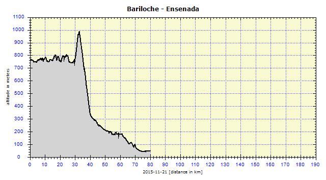
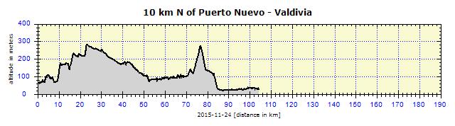
I set off at 12:40 on the 30-km route. The small buses transporting passengers made it in two hours. It took me a little over three hours; the ferry would be departing at 16:00. The travel agent had already warned me that the first 3 km were steep uphill on a very bad road and the rest was downhill. He was right, the steep road with a surface of loose, fist-sized stones and gravel was very rigorous. The bends in particular were steep and broken up so badly that I had to push the bicycle on three occasions as my worn back tire was sliding too much. I was not bothered by this and cycled according to circumstances.

Paso de Perez: The border between Argentina and Chile in the saddle of Perez is at an altitude of 1022 m
Relatively early, I saw a gate made of tree trunks which indicated the border between the two countries as well as two national parks — Nahuel Huapi and Vicente Pérez Rosales. I thought the worst was behind me, but it was not over just yet. The road got even worse and the steep descent was on the edge of my skills. Naturally, I cycled with open pedals, so I could react quickly in the case of a fall. I seriously considered pushing the bike down in some sections. In the end it was not necessary to do such an absurd thing as to push a bicycle downhill, yet sometimes I really struggled to cope with such steep downhills.

Road to Peulla: Impressive mountain

Road to Peulla: Rocky, quite bad route through dense forest
At times, I paused to admire the snow-covered mountain peaks around me and the deep primeval forest through which I was passing. I could not waste too much time, as I needed a margin in case of problems with the bicycle. Sometimes it was not even possible to stop, such as the time I did not manage to brake sufficiently to stop at an attractive viewpoint. I did not want to walk back up, even if it was only 100 meters. With the decreasing altitude, the road inclination decreased and the really relaxing part started when the road reached a river in the valley.

Road to Peulla: Turbid, brownish-colored river

Road to Peulla: Road leading along the river
That was when I could start enjoying it fully without any cares. Several waterfalls were located beside the road and there were plenty of them also on the more distant mountainsides around. The first signs of civilization appeared close to Peulla, such as a fenced grassy field with grazing cattle. Then I cycled past a farm, two colored houses and, after about 3 km, arrived at the Peulla Customs. It was 15:10, so I was only half an hour slower than the microbus carrying my fellow travelers.

Road to Peulla: Cascáda Las Mellizas - one of the many waterfalls

Road to Peulla: Signs of civilization near Peulla - fences

Road to Peulla: Lama

Road to Peulla: Colorful houses near Peulla

Road to Peulla: Near Lago Todos los Santos
On the way, I ate almost all the food that I had prepared. Two remaining sandwiches which I'd made with jamón crudo, cheese and hard-boiled eggs I placed in the back pocket of my cycling top, over which I wore a windbreaker. I lined up for 15 minutes at Customs. I arrived at the same time as another tour group which was headed in the opposite direction – to Argentina. I received a stamp immediately, but they called a Customs officer to check my panniers. I informed him nicely that I would open everything he liked, but also that I needed to board the catamaran at 16:00. He was not so strict, asking me what my panniers contained, so I named the stove, computer, tent, sleeping bag, clothes, spare parts – simply everything I could name in Spanish. He asked me to open the technical and handlebar bags. He tapped my shoulders and said: "You can go, amigo!" I had over 1 km left to reach the harbor and my fellow travelers applauded me when I arrived.

Puerto Peulla: Small waterfall right at the harbor

Puerto Peulla: Leaving Peulla
I took off the bags, placed them in a small container on the pier, which was eventually lifted on to the ferry by crane. I handed the bicycle from the pier to a tough-looking woman – a crew member – who tied it to the rails on the foredeck. I enjoyed a half-liter can of beer which I had taken with me in foresight, walked along that little pier and exactly at 16:00 we bounced off from the pier.

Lago Todos los Santos: Foot of large waterfall

Lago Todos los Santos: Very high waterfall, over 100 meters
The voyage over Todos los Santos Lake was once again a real experience. Surrounded by a circle of snow-covered mountains, with crystal clear water beneath us. The crew members pointed out the natural and other sights, both in Spanish and a slightly shortened version in English. The most outstanding were the volcanoes, first of all, Puntiagudo and then the photogenic crater of Osorno volcano. I got to see the third significant volcano, Calbuco, that evening from Ensenada.
")
Lago Todos los Santos: Putiagudo volcano (2493 m)

Lago Todos los Santos: Residence on a private island
")
Lago Todos los Santos: Osorno volcano (2552 m)
The almost two-hour voyage was very touristic, taking us even to a waterfall over 100 meters high and switching off the motors for a few minutes so that we could enjoy that beautiful scene. However, I had some problems. I had no Chilean cash, as earlier mentioned. In Bariloche they'd had none, either in the Exchange offices or in the banks. Not even the street currency sellers would exchange my USD. They would only exchange them if I bought Argentinian pesos. I let it be, they would surely have ripped me off, what else could they live from? I tried it in a store on board the ferry, where even the embossed payment card was accepted (they did not have an online connection, but used an old device instead). They said if I'd had Argentinian pesos they would have exchanged them for me, but they did not have the possibility of exchanging dollars.

Puerto Petrohué: Busy Saturday traffic in the harbor

Near Petrohué: Volcanic soil and its source - Osorno volcano
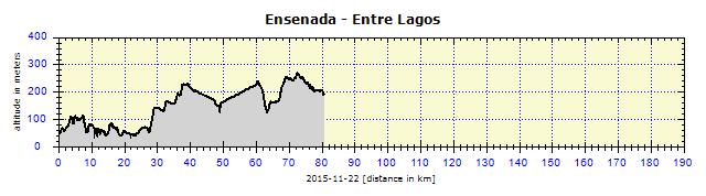
I put the panniers on to the bicycle when we reached Petrohué and headed off, quite hungry, on to the miserable dusty road towards Ensenada. After 5 km, I was amazed at the change, suddenly a quality paved road appeared, with a cycle path of approximately one meter in width on the right side. Thumbs up!
When I entered Ensenada, I stopped at the first kiosco (although there it was called a minimercado) and tried asking if I could pay with my card. “Of course, no problem” I carefully asked if there was any "cajero automático" in the town. "Go back to the crossroads, the only ATM is at the carabiniers." Good news, I was curious whether the ATM would deliver any cash. My first attempt failed, I selected that I had a Visa card. Bueno, at the second attempt, I selected that my card was international and soon I heard the crackle of banknotes being delivered. There was generally no problem with bank cards in Chile, they did not even ask for my ID when I paid by card in stores, as they did in Argentina and Uruguay. For that purpose, I usually used my international driving license, so that I would not need to remove my passport from its waterproof cover.

Ensenada: Osorno volcano at sunset
It would have been difficult to camp on that land full of volcanic sand which would get into everything. That is why I welcomed a "Camping" sign. Unfortunately it was cerrado (closed). I cycled 1 km further to Llanquihue Lake and inquired about a campsite at a restaurant. Once again, I was sent back to the crossroads where the carabiniers were standing. There were supposed to be two campsites in that area. They were right, for about CZK 120 ($6) I had my grassy spot with a table, electricity plug, faucet, just 50 meters from the lake. As I was slowly approaching the end of my journey, I started to eat my emergency reserves, I made spaghetti with tuna and reserved one more portion of it for later.

Ensenada: The sun sets over Lago Llanquihue
The following morning, while eating a can of sardines from the reserves, I decided on my next move. I wanted to avoid places I'd already visited four years previously. So, instead of continuing to Puerto Varas, I would take the route around Llanquihue Lake to Entre Lagos. It became apparent that I would not have enough time to make it to Santiago and that I would have to travel part of the way by bus. It seemed as if I would make it by bicycle to Temuco.

Ensenada: Entrance to Vincente Pérez Rosales National Park

Near Ensenada: Quality cycle path on side of the road
It was a great road with a dedicated lane for cyclists, which was even respected by drivers. The road continued to Las Cascadas, where a slightly corpulent lady called out to me that she was selling strudel. As a reflex, I turned around and parked next to her stall. The strudel was very tasty, not overpriced (CZK 30, $1.5) and, moreover, I posed for a memorable photo. The photo did not turn out to be one of the best. Although the ladies presented themselves at their best, we men (their son and I) made monkey grimaces. Most importantly, the women turned out well in the photo.

Las Cascadas: Souvenir photo in front of kiosk where I bought a great strudel

Las Cascadas: Flowers

Las Cascadas: Cemetery

Las Cascadas: The hostel looked liked a UFO
Another variation on my journey took place soon afterwards. A police car with siren blasting went by without any obvious reason. I had already seen that before in Mexico, so I knew a contest was about to begin. That time in Mexico it had been a motor race, this time it was a cycle race. The competitors came from the opposite direction, the leading group and peloton were so focused on their outcome that they did not even notice me. However, their company greeted me excitedly, honked their horn, waved. I also received the same greeting from the last group who had already lost the chance of a good place.

Junction to Entre Lagos: Cycle race

Junction to Entre Lagos: Racing cyclists whizzing past my special lightweight bike
About one hour later, the siren and racers returned, coming in my direction. The race started and ended in Entre Lagos. For the fun of it, I joined them, only to feel disappointed when I realized I could not catch up with any of them. I would have to train a bit harder.

Lago Rupanco : Beach near Río Rahua

Near Entre Lagos: Capilla Nuestra Sra de Mayelhue
When the race fever ended, a heavily loaded bicycle appeared from the opposite direction. It was a German cyclist, Stefan. He was heavily-laden and even had a backpack of at least 40 liters on his back. We talked for about an hour, ignoring the light rain. He had been on the road for 13 months, had crossed Africa and wanted to finish his trip in South America. He had not been to any other places yet, so wanted to know about my adventures. I gave him my contact card and he said he would contact me.

Near Entre Lagos: Stefan, a German cyclist
A well-equipped campsite, right beside Puyehue Lake, was located in Entre Lagos. Apart from tent sites, they also had shelters with lights and electrical plugs. Shortly after pitching my tent, it started to rain, so it was truly pleasant to be able to sit in a dry spot and write my blog. The WiFi also worked, although with frequent drop-outs due to the rain. There was also an older couple of motor-bikers from the USA and a young couple in a small motorhome, also from the USA. The first couple were soon to end their trip, the latter would end it when they ran out of money. They were headed to Argentina. I suggested that they take the route on the RN40 to San Martín de Andes.

Entre Lagos: Puyehue campsite is named after the lake

Entre Lagos: Superbly equipped campsite: shelter with light and socket, both functional

Entre Lagos: Late afternoon at Lago Puyehue
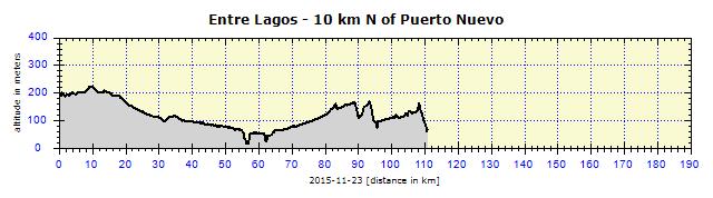
I borrowed a map from them and located an unpaved road leading almost directly to Río Bueno. I made up mind to take that road. The road turned out to be OK, and thanks to the rain it was not very dusty. That changed by midday. Luckily the traffic was minimal, about 15 cars over the 40-km distance.

Chirre: Wooden church
")
Crucero: Animals here are in paradise (before being slaughtered for meat - horses too)
My first steps in Río Bueno were to a big supermarket, where I supplied myself for my further travels and also had my lunch. I started searching for a road map, but it was impossible. There was not one for sale anywhere, either in a newsagent or gas station. I was sent to the Municipality, but they were on a lunch break until 15:00 (allegedly at 15:00, this was South America). The Museum was also closed, but the lady working there opened the door. We went through all their tourist brochures and found two with some maps of the outskirts. The huge lake Lago Ranco was 50 km away, so I was headed there.

Lago Ranco: Sunset colors the opposite mountains
I arrived in Puerto Nuevo, a small village 2 km from the lake. No campsite, the nearest one was located in Futrono, 25 km distant. The road was quite hilly, but I could not camp near it as the pasture fences were just five meters from the roadside. Although it was possible to pitch my tent there, I would have been too visible, and I did not like that. The road descended to Lago Ranco and I knew I would find a place there. I found a handy grassy spot, hidden by high overgrown bushes, so it was not visible from the road. A perfect spot, water only 20 meters away, which I filtered with my SteriPen for drinking and cooking. I could wash myself thoroughly, there was nobody around, I took off my clothes, jumped into the ice cold water and was immediately clean. My chattering teeth only calmed down after the freshly brewed coffee.

Lago Ranco: Last of the year's camping 'in the wilds'
Then I sat by the lake for about an hour, drank good, cheap Carménére and observed the light changing at sunset. At night I was awoken by the loud squawking of birds. They were squabbling so much over the trash I had hung in a plastic bag on the handlebars that they knocked down my bicycle. They dragged the trash all over and I had to pick it up in the morning, otherwise I would have felt like a scumbag. It was 02:00, but I did not regret being woken up, my reward was to see several bats circling over the lakeshore to complement the glittering stars.

Lago Ranco: Sunrise over the lake
In the morning, I was no longer keen on bathing again, so I only washed myself. I watched the sunrise and planned my next move. If I continued on to Temuco, I would cycle for about 100 km on the same road as I'd been on four years ago, although in the opposite direction. I had already seen enough of the lakes and decided to see the Pacific Ocean. By the way, here you clearly see how detailed my travel plans are and that I do not take a step without thorough planning!

Lago Ranco: Blue restaurant near Futrono

Lago Ranco: View of the lake and distant Andes
So I cycled around Ranco Lake and, instead of heading to Futrono, turned sharply westwards. After 50 km, I crossed Road 5, a famous Panamericana. This was the only place where I crossed over the same route as four years before. I used the Panamericana to cycle southwards from Los Lagos to Osorno.

Near Reumén: Panamericana Highway 5 - the only repeated section I’d cycled 4 years before
Another 50 km, one hour in abrupt rain and I was battling through the dense afternoon traffic in the big university city of Valdivia. The GPS located a hostel for me, but it only had a bed in a shared bedroom. I did not take that. I tried at another two hospedaje in the area, but they claimed to be fully booked. Finally, I found accommodation in a hospedaje for about CZK 450 ($23). It was clean, but otherwise not very good. The WiFi functioned well.

Near Valdivia: A pair of swans with their young
Valdivia
I went to watch the sea lions on the embankment, ate a steak in a local food hall and studied the guided boat excursions. At a bus station, I purchased a ticket for the night bus to Santiago for two nights in advance. The ticket price turned out to be the same as the accommodation in the hospedaje. The seat I booked was semi-cama (half-bed, the second best class) on which people of slighter figure can comfortably sleep. Naturally, I chose the Turbus company, which I knew from the past would not have any problems in transporting a bicycle. Although the lady said something about taking it apart and packing up the bicycle, I was not going to make such an effort. I knew I could push it in in somehow in its whole form.

Valdivia: Hotel Dreams in which I did not stay

Valdivia: Seals and cruise ships are two of the three main attractions of the city

Valdivia: I satisfied my desperate hunger with Churrasco at an ordinary restaurant

Valdivia: Nutritious Chorrillana in the local cafeteria

Valdivia: Feria Fluvial - daily fish market on the waterfront
Valdivia is quite a big city of 140 000 inhabitants, surrounded by four big rivers: Río Valdivia, Río Cruces, Río Cau-Cau and Río Calle Calle. The city contains several universities, the biggest one being Austral de Chile. This also influences the make-up of the residents which consists of many young people. Those, however, take up most of the cheap accommodation, which makes it difficult to find accommodation even when out of season.

Valdivia: For 500 pesos you can bring home a living friend, which looks at you curiously from its shell

Valdivia: Fish are filleted by experts, a pleasure to watch

Valdivia: Some seals are so lazy that they climb into the waste gutter, where the cutters throw fish remnants

Valdivia: I asked them to smile, but in vain - they showed me their cold noses all the time
The greatest attraction is the sea lions, lazing on several rafts beside the embankment. The second highlight is the vibrant, attractive Feria Fluvial fish market, where fresh fish and other sea products are purchased at good prices. The fish litter then feeds plenty of cormorants, seagulls, pelicans and of course even the sea lions. The most arrogant ones pushed themselves into the litter canals and fishermen cutting the fish threw the remains literally at their heads (heads, spines, intestines, flippers). They needed to shake their heads every now and then to receive another portion without any hard labor.

Valdivia: Submarine

Valdivia: Submarine

Valdivia: Sailors lowering a flag

Valdivia: Libertad Street in the city center

Valdivia: Portal Teatro Cervantes recalling the good old days

Valdivia: A few remaining towers in the city, formerly part of original city fortifications

Valdivia: Foucault’s pendulum
Another attraction is a cruise on the Pacific Ocean. All include meals and I realized why only when I went on one. In general, the voyage is quite boring, so they need to entertain people with food and drink. The cruise to the Pacific Ocean took two hours, the scenery did not vary much and it rained most of the way.

Valdivia: On the cruise ship before departure
Then the boat anchored at Mancera Island and we walked to a Spanish fortification. Only some of us took that walk in the heavy rain. I had taken my rainproof clothes with me as a foresight. The next stop was Fuerte Corral (fortification), which we had to skip due to the rough waves. The Captain tried getting closer, but the boat was tossed about so much that all the utensils still left on the tables were broken. Then we headed back, only on another river. The cruise took six hours. In any case, I ate well and was sheltered from the rain.

Isla Mancera: Walls of the fortress and tower of local wooden chapel

Isla Mancera: Coast at the dock

Valdivia: Juniors training in double sculls
The weather cleared up towards evening and I thought that my cycling trip to the Pacific the next day would be in good weather. I ate dinner in the same food hall as the day before. They already remembered me there and the lady called to me: Hola Jorge! (of course, I did not tell them to learn my Czech name of Jiří).

Valdivia: Modern building in the garden of one of the local universities

Valdivia: Part of the impressive mural devoted to human rights
My weather expectations were wrong. It rained the whole night and continued the following morning. That was why I stayed in the hospedaje until 10:00 when I had to check out. I left in a mild drizzle, which stopped soon afterwards. I was not in a hurry to get anywhere, the bus departed at 22:15.

Near Valdivia: Christmas tree decorated with 5-liter barrels at Kunstmann Brewery

Near Niebla: Boat on Rio Valdivia, Isla del Rey in the background
I went to see the fort of Niebla, it was closed. I continued on the coastal route along the Pacific. The cheap coastal road did not provide any comfort, it simply copied the terrain, which resulted in steep parts, luckily usually short. I had to cycle those parts in the lowest gears.

Niebla: Burnt out building - remains of equipment

Niebla: Burnt out building - detail of window frame

Los Molinos: The dock is already in the Pacific
After San Ignacio, the asphalt ended and the dust road began. The wheels lurched through the top 3-centimeter layer of viscous mud. Both the bicycle and I were totally soiled. In Curinaco I turned away from the ocean and started returning to Valdivia.

San Ignacio: High waves of the Pacific would be attractive to surfers, if it were not for the coastal rocks

Near San Ignacio: A large building on the promontory. It is completely empty, its purpose unclear

Curiňanco: Last view of the Pacific, followed by a very steep climb
The road ascended really steeply and was very demanding. I even had to push the bicycle for about 50 meters uphill. Interestingly, the dust road was paved in the steepest parts. Whenever I spotted asphalt ahead of me, instead of being happy, I moaned, "This will be something else again...". After several km, I made it to the top. Meanwhile, it began to drizzle continuously. Such rain is usually not taken seriously, until one is soaked through. I already knew that, so I put on my waterproof pants and jacket in time. The descent was on an unpaved road without any asphalted parts, muddy after the rain.

Valdivia: I gave chicken bones from lunch to the dog, and she in exchange guarded my bike
Back in Valdivia, the critical mud-plastered state of the bicycle, panniers and myself required something to be done about it. I inquired at two gas stations, but they only had a drive-through car wash, no hand-washing was available. I had an idea, remembering the hosepipes at the fish market. It was about to close, so I borrowed a hose from one of the fisherwomen and washed everything thoroughly. It smelled of fish, but was clean. Then I ate, purchased supplies for night travel in bus and cycled around Valdivia and then to the bus terminal after 21:00.