| Cycling South Africa |  | |||||
 |
 |
 |
 |
 |
 |
 |
| Nothing compares to the simple pleasure of a bike ride. J.F.Kennedy | ||||||
| Three-month cycling trip, starting in late August 2012 in Windhoek, ending in Cape Town. Author's 9th expedition (New Zealand, Australia, USA, Canada, Alaska, Japan, Mexico, Bolivia, Chile, Argentina). |
|
Along the Indian Ocean Shores
Port Elizabeth
The nicest part of the central area is Donkin Hill, which rises about 70 meters above sea level. There are many historical buildings, a park, a lighthouse and churches. But unfortunately it is in the wrong area, and it is definitely not safe at night. In the city center, all the stores close at 5 p.m. After that, there is no sense to be present there. Another very attractive location is St. George's Park, a well-maintained park with lush tropical vegetation. At night it is closed and during the day is watched over by Police. Even so, I was the only person there. Not even joggers go into the park, preferring to run in the road around the park. Better situated people have simply relocated to Humewood and Summerstrand, about 4 km south of the center, where there are beautiful sandy beaches, a casino, shopping mall and where it is perfectly safe.
Addo Elephant National Park
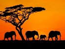
The area north of Port Elizabeth is very fertile, due to the favorable climate. Citrus fruit is traditionally grown there. Before the arrival of the settlers, there had been a considerable amount of wildlife in this area – elephant, rhino, lion, buffalo, antelope. The settlers began to establish fruit-growing farms, but the large animals, in particular elephants, were thwarting their efforts. Therefore, the animals were slaughtered on a massive scale by the farmers. The farmers, however, were unable to complete the task and so, in 1919, they hired Major P.J. Pretorius to exterminate the remaining elephants. The Major was quite efficient. In two years, he shot 114 elephants and even managed to sell two captured calves to the circus. This led to a change in the opinion of people and the slaughter was halted under pressure from the public. The remaining 16 elephants were given refuge on the lands of farmer J.T. Harvey.
In 1925, Addo National Park was established on 5,000 hectares where the remaining 11 elephants were herded. The Park was unfenced and so the elephants continued to damage crops, thereby seriously annoying the farmers. The Park Manager came up with the idea of providing food for the elephants in order to keep them within the Park's territory. Every day a truck delivered oranges, pineapples, pumpkins, hay and alfalfa. It was good for tourism because the elephants all gathered together in one spot. But it also created problems. The elephants stormed the feeding place, taking oranges with their trunks directly from the truck, and often fighting each other for food. They remained in the vicinity of the feeding area all day, especially fearing that they would miss their favorite oranges. Thus not only did they devastate the landscape, but also each other. Their offensive behavior resulted in many injuries. Feeding of the elephants was stopped in 1979. Instead, the National Park was fenced in with resistant fencing of posts and thick cables. The fencing was a success and now more than 500 elephants live in the Park. The fence works perfectly, thus far only only two elephants having managed to escape. The most famous fugitive was one named Hapoor, an elephant who was the leader of the herd for 24 years. He was only replaced in 1968 by a young elephant who expelled him from the herd. In that year, the 44-year-old Hapoor managed to climb over the Park fence. His ending was bad, and he did not enjoy his freedom. He was shot by rangers, due to his aggressive behavior. As it was raining heavily, it was clear that we would not see many animals. Nothing forced them to go to waterholes if they could drink from any puddle. Fortunately, we were traveling in a covered vehicle during this part of the trip. Our guide, Peter, was trying hard to show us some elephants at close range. He consulted with other rangers, but even they were not lucky, the elephants were out of sight. The Park is enormous and elephants often are seen on their own. This is in contrast to Etosha, where elephants have a greater sense of family life and roam together in herds of approximately 25 individuals.
At the Park entrance, there were large signs requesting drivers not to drive through elephant excrement. Dung beetles, the size of a child’s fist, live in the dung heaps. Naturally, a tire smashing through the heap would kill them. An adult elephant produces 175 kg of feces per day, during which he consumes 200 kg of leaves and other vegetation. I do not understand how elephants can grow to such enormous proportions on that remaining 25 kg.
Bingo!
Schotia Private Reserve
Indeed, my money was well spent. Rangers have a complete overview of the movement of the animals and so we saw many examples of the wildlife living there. The rhino were beautiful. Suddenly they were about half a meter from our vehicle. If I had so chosen, I could have gripped a horn. Fortunately, these were peaceful white rhino. Black rhino would probably have trampled us into the ground. We saw also giraffe, wildebeest, impala, eland (the largest of the antelopes), kudu, zebra, hippo, crocodile and many other animal species. In addition, I also saw a mongoose, which I encounter on a daily basis because it is written on the frame of my bike.
Lions at Last
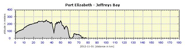
Jeffreys Bay
Finally, I cycled along the original old road to Cape Town. Road 102 was used before the building of the highway and now is a little frequented local connection. The first 20 km after leaving the city were problem-free. In the meantime, I managed to solve a linguistic mystery with which I had actually struggled from the beginning of the journey. Whenever I asked for directions in a city, I was often told: "go to the second robot and turn left." Sure, but what did "robot" mean? Initially I thought it was a roundabout, but this did not make sense. Then I realized that it meant a crossroads controlled by lights. I was reconciled with the meaning, although I kept wondering what a strange word it was. The mystery was revealed when I saw the sign: "robot" in the road before an intersection. So, Czech writer, Karel Čapek is to blame for the commonly used designation of "traffic lights" in South Africa. Further on, the road had a satisfactory verge for about 15 km, so I did not have to watch the traffic in the rear-view mirrors. The verge disappeared, but the traffic significantly decreased as well. An hour later, I reached Jeffreys Bay. I wanted to go to the campsite, but they wanted 220 Rands for a tent site. This did not seem fair to me, so I leafed through a Backpackers booklet and had success at the first one. I took a room for 200 Rands. It was a suite of two rooms, with a bathroom and toilet, a lobby and kitchenette. I was alone, so the conditions were just luxurious. The hostel was in a great location, 30 meters from the beach, 50 meters from a SPAR store, a 15-minute walk to the town center.
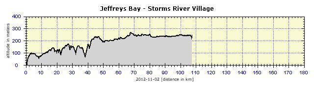
Jeffreys Bay was originally a small insignificant settlement. In the 70s, surfers discovered the great waves there. The surfing conditions there are reputedly the best in South Africa. Every year in June, the World Cup of Surfing is held there – on the Supertubes Beach –where I was staying. The town lives from this sport – surfing equipment rentals, surfing schools, clothing stores. I even saw a small Museum of Surfing on the first floor of the largest surfing equipment store. Besides surfing, people come here to swim. There are extensive sandy beaches where surfing is forbidden so that swimmers are not at risk. An important role is played by the significantly warmer water than in Cape Town, where the waters of the Indian Ocean mix with the cold Atlantic. The conditions are accompanied by a real estate boom, all the houses are new or in a very good condition. There is a wide range of accommodation choices and many stores selling alcohol.
Storms River
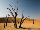
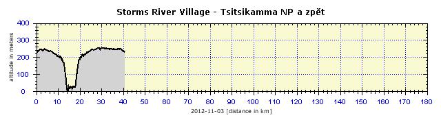
The rivers have a tough time, with each one having to carve its own canyon through the coastal rocks. The hills stretch out at an altitude of about 200 to 250 meters down to the coast and then there is a sharp drop down to the ocean. Therefore, there are many waterfalls, albeit inaccessible. I cycled across the Storms River Bridge, about 10 km from the river mouth. The canyon is at least 100 meters deep, but very narrow, the rock is probably pretty hard. In the photo, it is not obvious at all, only a dark line is visible of the canyon and no light penetrates down to the water stream.
Storms River Village is a small settlement, existing exclusively from tourism. I stayed at a Backpackers. Instead of paying for a room, I preferred to camp out. The beautiful grassy area actively encouraged this and the weather was also good. A bonus was the cheap price and the option of taking advantage of the hostel facilities: kitchen, showers, evening fire and even WiFi. Although the rate for WiFi was 20 Rands per hour, with the price of 70 Rands for the tent site, it was not a problem. A private double room cost 350 Rands, an unnecessary expense for a lone traveler. Single rooms are usually not available and only the smarter entrepreneurs offer a room at a better rate to single travelers. The “American” restaurant in the village, with a polished Cadillac and Chevrolet, photos of Presley, Marilyn Monroe and the Beatles, gave the impression of something out of sci-fi. The music never went beyond the 60s, with a typical American menu and surprisingly very tasty food. I was there boots and all, and enjoyed two dinners there with gusto.
Tsitsikamma National Park
The main attractions of the Tsitsikamma National Park are the waterfalls on the Otter Trail. This is a five-day trek along the coast, reportedly very demanding, with several river crossings. It is usually sold out a year in advance. Its initial part is conceived as a day trek to the waterfall. I could not miss it and so I cycled the 13 km to the National Park. The trek was very difficult, especially in cycling shoes. Roughly half of the 4 km-long route led across coastal rocks and I was very careful to avoid my feet slipping on the shoe clips. There were narrow gaps in the rocks, in which a foot could get stuck and, with a bad move, cause ankle or knee injury.
Another attraction is the Storms River Mouth where the river flows into the sea. The canyon is still narrow, albeit a little wider than under the bridge, impressive, but not photogenic. The mouth is spanned by a suspension bridge accessible via two other suspension bridges. The site is extraordinary, seals frolicking in the river and the surrounding flora dominated by majestic white Arum lilies.
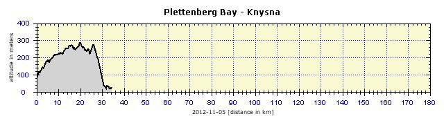
Plettenberg Bay
There was only a phone number at the first Backpackers. It did not matter, about 50 meters further on there was another one where I dropped anchor. Although it was a Sunday, three big supermarkets were open, so there was no food scarcity. Then I ran down to the ocean and, when it finally got dark, ended up in a Sushi restaurant, to relish the difference from my usual diet.
Minor Defects
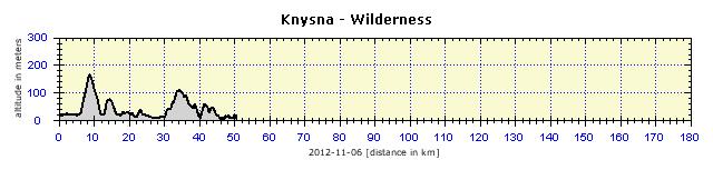
Knysna
The dense settlement has its advantages. My food bag had already been almost empty for several days. There was no need to build up any food stock, as in Knysna, the choice was abundant. 250 meters from the Backpackers there were four major supermarkets – SPAR, Shoprite, Checkers and Pick n Pay. My favorite was SPAR, as they stock a varied range of products, for example, also European cheeses and a wide assortment of ready-to-serve meals, and they also had the shortest lines at the checkout. And because the Backpackers had a microwave, it was no problem to enjoy a quality lunch or dinner cheaply. However, the Knysna SPAR exceeded all my expectations – the local fishing cooperative has a counter in the store selling freshly-caught fish. The fish are already cleaned and deboned. I could choose from eight types of prepared fillets. I chose three types – that is, three fish halves, which they immediately cooked naturally, in less than 10 minutes. To go with this, I bought some ready-cooked vegetables and a great dinner was taken care of. With the basic needs secured, I could go sight-seeing. There are not many. About 30 km from the town is an area with freely living elephants through which several hiking trails lead. The number of elephants in this area is debatable. An optimistic estimate is that three individuals live there, but there are also opinions that there are no elephants any more. Therefore, seeing an elephant equals a miracle, and that is also why it is possible to walk there. The greatest attractions are the local lagoon and Thesen Island located in it. 90-minute boat trips are organized on the lagoon. It was clear to me that, with a nice sunset, the cruise would be pleasant. The sky began to clear, so I bought a ticket. Unfortunately, before departure at 6 p.m., the sky definitely clouded over, which affected the voyage significantly. The cruise was limited to the lagoon and did not go out into the open sea. The gap is 60 meters wide, 20 meters deep and guarded by limestone cliffs called 'The Heads'. Englishmen have been shipwrecked several times when trying to sail into the lagoon, and therefore the entrance to the lagoon is considered as one of the most dangerous port entrances in the world. I have to agree with the classic “It does not seem so from the outside”.
Nomen Omen: Wilderness I arrived at Fairy Knowe Backpackers, 2km further on. With satisfaction I noted that it was just to my taste. The owner was one of those who enjoy providing accommodation and consider it his mission in life, and of course, it also pays the bills. I pitched the tent, as the only one there. However, before that, I familiarized myself with everything I could do there. It was a program for a week or so. I quickly washed my sweaty clothes, the hills were not dizzyingly steep, nevertheless I had sweated somewhat. And then I set off on the 10-km trail to the waterfalls recommended by the owner. He lent me a pass to the National Park, which saved me 90 Rands. The Half Collared Kingfisher Trail leads through the deep woods along the Touws River, more difficult sections lead along a boardwalk. Half of the trail can be kayaked and the rest covered on foot. Kayaks are available to rent at very low rates in the hostel, but all are for two persons, and I was unable to find a sidekick. But it was a pleasant and easy three-hour walk. The Touws River is crossed by the Trail in two places. One place was a pontoon, which I pulled on a rope from the opposite shore, comfortably crossing the 7-meter narrow river. Another possibility was about 500 meters further on, which was to jump across the rocks to cross the river. I left this to others, the pontoon suited me well. Birds sang, everything smelled of spring, the river roared, the perfect picture only lacked a pub or a kiosk at the waterfall, through whose smoke-blackened windows a tired man could watch the natural scenery while pouring some refreshing drink down his throat.
Show Me the Highway
The highway to Mossel Bay began before George. Neither of the maps that I was using (map of South Africa and road map of the Western Cape) clearly defined the alternative road, the traditional and original R102. In the GPS I saw the side road, because a few days before I had bought a GPS map of the Western Cape province online. It was very accurate and, what was most important, it listed all the accommodation establishments. I would have had to go through George, wriggling my way through all the traps of everyday traffic. I do not really enjoy cycling on highways, but resolutely entered it, curious to see how the local cops would react. It is true that many people were hanging out with kids and dogs on the verges, because they were taking a shortcut from the adjacent township. It turned out just as I had expected. About 20 police cars passed me indifferently and it did not occur to them to stop and reprimand me. Thus far it had been like that everywhere – surely the cops would not hassle some poor foreigner (bike, flag) from whom no profit could be expected, and in addition, for the sake of safety, whom they would have to lead to a normal road (as would be the case in the U.S. and Canada). With the 2-meter wide verge, it was very safe for me. No complicated intersections with other highways, only the usual exit and access roads where it was no problem to pay extra attention. Only one section was critical – a steep descent down to the river where the bridge narrowed to just two lanes and no space was left for a verge. I waited in the middle of the hill until no car was in sight and then speeded down towards the bridge. I managed it just in time, a wood-carrying truck crossing the bridge just behind me. This ceased to entertain me, so I dropped out on to the parallel R102 which emerged next to the highway. After 10 km, the road took me back on to the highway, so I finished the route on it. In Mossel Bay, I came across a bike store in which, oddly enough, they had a spare holder for my cyclocomputer. There were about 10 cyclists in the store, and it seemed to me that they were speaking Russian. This was a group of men and women from Ukraine who were traveling without luggage from Jo'burg to Cape Town. A minibus drove behind them with the luggage and a carrier for the bikes in case somebody got tired of pedaling.
Originally I wanted to go to The Point Caravan Park, but I did not like the place and also the price distinctly exceeded the quality (190 Rands). I found a Backpackers a short walk from the center for 230 Rands, with shower and toilet in the room, and very good WiFi just for good measure (so I slept badly again). I walked through the town center which is situated several meters above sea level and offers very scenic views. I liked the local lighthouse. Hopefully you enjoy seeing my photos. The following day I would depart the Indian Ocean shores for some wine-tasting in the local vineyards.
       |


