| Cycling east Canada and USA |  | |||||
 |
 |
 |
 |
 |
 |
 |
| Nothing compares to the simple pleasure of a bike ride. J.F.Kennedy | ||||||
| Statistics |
| Map of route |
| Miscellany |
| Profiles |
| Selected photos |
| E-mail the author |
| Writings from a trip |
| Québec |
| Newfoundland |
| < Nova Scotia > |
| New Brunswick |
| Maine |
| Massachusetts |
| New York |
| Washington D.C. |
| Virginia |
| Carolinas |
| Florida |
| Other trips |
| List of trips |
| Search |
| Four-month cycling trip, starting in late July 2013 in Quebec, ending in Orlando. Author's 10th expedition (New Zealand, Australia, USA, Canada, Alaska, Japan, Mexico, Bolivia, Chile, Argentina, Namibia, South Africa). |
|
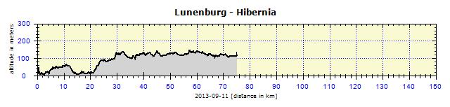
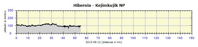
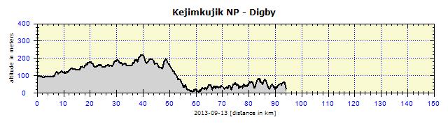
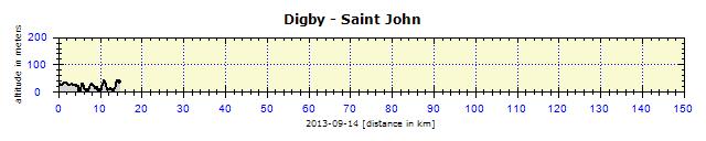
Nova Scotia North Sydney, Englishtown, Ingonish, Cape North, Bay St. Lawrence, Cape North, Pleasant Bay, Chéticamp, St. Rose, Inverness, Mabou, West Mabou Harbour, Judique, Port Hastings, Havre Boucher, Antigonish, New Glasgow, Truro, Urbania, Shubenacadie, Fall River, Bedford, Hammond Plains, Halifax, Peggys Cove, Tantallon, Hubbards, Groves Island, Chester, Mahone Bay, Lunenburg, Bridgewater, Colpton, South Brookfield, Hibernia, South Brookfield, Caledonia, Kejimkujik NP, Miford, Annapolis Royal, Digby - ferry - Saint John
Around Cape Breton
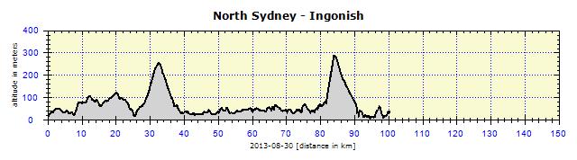
As there was no other route, we started out on the TCH (Trans-Canada Highway). We undertook the first ascent to 240 meters and then turned on to a side road leading to Englishtown. Fortunately, it stopped raining and it always becomes easy peasy once the Gore-Tex is removed. One does not sweat any more and the wind does not only ruffle the remains of the gray hair, but also the whole body. We crossed St. Ann's Bay on a ferry which continuously shuttles non-stop across the 80-meter wide strip of water. From there, the road led us on to a 2 km long, several meter wide stretch before we reached Cape Breton Island.
We reached our intended destination campsite in a flash. As it was still early, we proceeded to the Ingonish site, 50 km further on. We got to know our first local steep hills. They are not very high – Smokey Mountain is only 370 meters – but they are really very steep. I was hard-pressed to cycle uphill in the lowest gear, especially in some sections where the strong headwind roared into my face. It was later confirmed by the locals that these hills are the steepest in the whole of Canada. The campground was located right in the Cape Breton National Park. Alain paid the park entry fee ($6 for seniors) but I cycled past the registration hut without paying – they were already closed by the time I entered. I checked whether there was any self-service registration, but there wasn't. And since there was no other way to pay that fee, I swindled the Canadian taxpayers out of six loonies. I hope they will forgive me. One of the advantages of traveling in twos is the lower camping costs. Our two small tents easily shared one pitch, often intended for monstrous RVs (recreational vehicles). We pitched our tents a fair distance apart, only sharing the table. Alain is a whizz, he always talks exhaustively when registering, so when I arrive a quarter or half an hour after him, I am greeted by name (sometimes by my surname, when they confuse the two) and with detailed instructions of where to find Alain's tent.
The next day, we agreed to reach the campground in Chéticamp. I was slightly unfit. I set off about half an hour after Alain, battling hard to pedal. This does not happen very often – I suspect it was caused by the too abundant breakfast. The body was busy digesting food and had no energy left for propelling the legs. On top of that, I was suffering from delusions. I thought I vaguely heard bagpipe music. A rock appeared around a bend, on which a bagpiper was standing and playing for dear life. People were photographing him from the parking area, but I joined him up on the rock to have a chat. He was a pleasant young man and the bagpipes were his hobby.
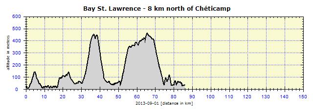
After midday, I met Alain and convinced him to change our plan, which wasn't so difficult as he also liked the scenery and was not in a hurry to get anywhere. We almost reached the northernmost foreland of Cape Breton and arrived at the Bay St. Lawrence campsite. Although we would have to return 20 km along the same road, we did not mind. Partly cloudy, but no rain in sight – we enjoyed the relaxation. We met some people from Finland who had lived in the States for a few years. They warned us to secure our tents properly, as it was going to pour. There were a few flat white clouds on the horizon, the stars were shining brightly that night, so we didn't really believe them.
Like a Water Sprite
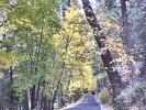
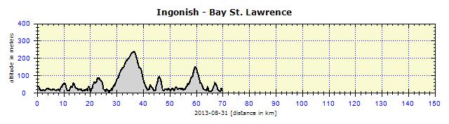
Next came the descent to the ocean – to Pleasant Bay, followed by another steep ascent to Mackenzie Mountain at 355 meters and French Mountain at 455 meters. Gore-Tex does not withstand a whole day of heavy rain. First, the sleeves get soaked. But one does not get cold, it just very hard to differentiate between what is moisture from the outside and what is from the inside – in other words, the sweat produced from the depths. Due to the rain, I could not wear glasses. The rain beat into my eyes, the road was damaged. I was straining not to go too fast and thus end up in a ditch. I was thinking about the night ahead, that we should not go into our tents soaking wet, but should at least sleep under shelter. At the campsite, I was welcomed as usual with the information that our pitch was next to a shelter. Of course, my buddy was no dummy. Things got much better. The shelter was, in fact, a cottage with tables and a sink, with a stove for heating in the middle. We bought some wood, lit the fire, swept out the pools of water on the floor with a broom and felt as if we were in the Hotel Ritz. The only thing that bothered me was that we had cycled through the best part of the National Park, seeing only the tops of the trees and rocks sticking out through the rain clouds.
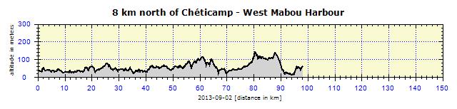
The weather there changes all the time. So, although the following day was cloudy, not even a drop of rain fell from the sky. I hung my partly dry jacket on a saddle-bag, and the wind dried it. All our other clothes were dry. Not even the shoes were very wet, because we'd stuffed them with newspapers overnight. 8 km later, we cycled through Chéticamp, quite a big city by local standards, with 3000 inhabitants. But that was no use to us anyway, the big supermarket was closed as it was Labour Day. Luckily I came across a reasonably good open store 20 km later, where I replenished my food reserves. I had been starving since morning, even though I'd had a standard nutritious breakfast (soup, bread with cheese, cucumber, bell pepper, oats, a liter of tea). Hunger forced me to stop at a pleasant roadside restaurant. There I enjoyed excellent soup, and equally good fish, of course without the chips, only with vegetables. It was no wonder – the restaurant was situated near a bayside fishing boat harbor so the fresh fish jumped straight into their pan.
Some areas on Cape Breton are occupied by the Gaelic community, so the local signs are in two languages: English and Gaelic. The Acadians are another minority group, a few of whom are descendants of the 17th-century French settlers in Nova Scoria, New Brunswick and Prince Edward Island. Considering the small population of Cape Breton, the society is very diverse. And one can easily tell at first sight who belongs to which community.
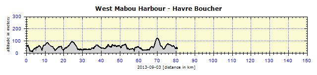
As usual, the next day was pleasant, although the weather was a bit cloudy. We spent almost the whole day on the Trans-Canada Highway. There was a lot of traffic, so cycling was not really pleasant, even though the emergency lane was a meter wide. Only on the hills, where there was a double lane in one direction, was the emergency lane absent. I was caught in a heavy downpour 5 km before the Havre Boucher campground. There were no shelters in the campsite, so we squeezed ourselves into a small laundry room. The dryer dried our clothes and we even managed somehow to cook a meal in this confined space. No point in pitching a tent in such heavy rain, my sleeping bag would only get soaked. The rain eased off slightly just before midnight and that was all I needed. I pitched the tent in the dark from memory and, once inside, couldn't have cared less about the rain outside.
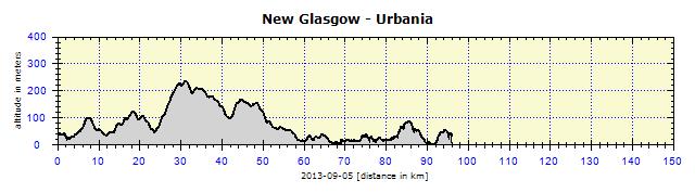
We cycled along the local roads parallel to TCH. A stylish town – Antigonish – with a university and several institutions of higher learning, parks, red-brick homes built in uniform style. In a large shopping mall, I had lunch in the supermarket. I bought a transparent plastic bottle with a wide mouth in a chain store for $1.15 to use for gas for the stove. Hopefully I could now have peace of mind when filling up at a gas station. Alain left me a message at the local Information Center with the name of a motel in New Glasgow. I arrived there later and slept in a bed again, for the first time in a very long while.
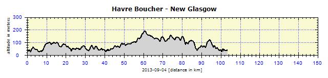
Morning looked like an image from a travel brochure. But they had already warned us at the motel that severe storms and heavy rainfall were on their way from two directions. They also warned us about the steep ascent to Mt. Thom. I was waiting the whole time for a steep ascent, but it turned out to be quite gradual. It was managed without any notable effort. The storm arrived after about two hours and was rather ferocious. To sum up: the whole day in Gore-Tex. In Truro, which is another fairly big town and regional center, I left the busy TCH and enjoyed the ride on a twisting local road through agricultural landscape. I met up with Alain a kilometer before the campground. We had not seen each other the whole day, yet we managed to arrive together. It was pouring. We were soaked, so we asked the owner if there was any roof under which we could cook. She had one cottage with a terrace where we could cook. Then she changed her mind and gave us the keys of the cottage – but at the price for camping. The rain stopped during the evening, so I pitched my tent next to the cottage. Alain slept inside. I always sleep better in a tent. Although the nights were starting to get colder, my down sleeping bag was still in a good state and warmed me nicely.
The specialty of this area are the tidal waves tearing down the Shubenacadie River. The river banks are gnawed away, wild waves ravage the riversides and the water is a turbid brown. This explained the disgusting-looking water, which was quite safe to drink. I filtered it, made tea with it, but it was still undrinkable. There was a viewing platform above the river in the campground, but high tide was only due the next day at midday and we did not want to wait. The rough waves are used for unique river-rafting, which is organized by several agencies. The locals take pride in having the highest tide in the world. I took that with a pinch of salt, as I had heard the same claim made in Derby in North-West Australia.
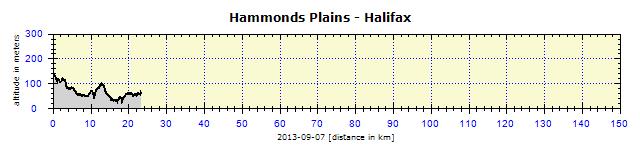
We were less than 100 km from Halifax. My strategy is to reach a big city, preferably before noon, in order to find accommodation. Advance reservations are not for me. We located a campsite on the map about 25 km from Halifax center in a pleasant lakeland setting. In the morning, I had a problem with the gas. The new bottle had cracked and half a liter of gas had leaked into my saddle-bag. Luckily, it contained only tools, a cooker, and chargers which were in a plastic box, so the gas did not damage them. Despite washing the bag thoroughly with water and wiping it with newspaper, it still smelled of gasoline. Later, I bought a liter of vinegar in a plastic container in a supermarket, poured out the vinegar and thus obtained a new bottle for the gas. This plastic material was a bit softer and looked as if it might last.
Halifax
There was a park across the street with an afternoon children's event on. Loads of free amusements. Even the cotton candy, popcorn and drinks were free. And, just as in our country, it attracted many people, with lines forming for everything. But in a very orderly manner. The weather was good and everyone was thoroughly enjoying themselves. The most unusual was a ride on electric-driven toilet seats.
Halifax Citadel
Then I strolled around the city, along the whole harbor promenade, ate well – in other words, enjoyed a well deserved rest after eight days of constant cycling, often in lousy weather. On the following day, I looked around the stores, buying a new light backpack to replace the old one whose bottom was falling apart and had gaping zippers. There was the risk of the contents falling out. I really would not want my camera, for example, to drop out on to the hard sidewalk. In the afternoon, it started to rain. This was a welcome chance for me to catch up on my arrears and add to this blog.
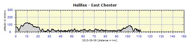
Alain and I agreed that an additional day in Halifax was unnecessary. We would cycle along the South coast of Halifax. It seemed as if we were to ride together all the way to Digby, where the ferry to New Brunswick starts. He would then probably head back home to Montreal and I would finally go in the direction of the USA. It all depended on the weather, though. Maybe I would also cycle through a part of New Brunswick.
South Coast
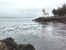
The small fishing village of Peggy's Cove is a popular attraction. First impression – many people and tourists everywhere, considering the size of the place. The lighthouse area is especially popular, it felt like Wenceslas Square in Prague. The village is small and most buildings around the fishing harbor are in a terrible state. However, at the same time very authentic. Fishermen live here and daily go out to sea to fish. I was hungry, but the overcrowded restaurant discouraged me from entering, it seemed as if there would be a very long waiting time.
The memorial for the tragic crash of Swissair Flight 111 is located about 2 km from Peggy's Cove. The plane crashed into the sea on 2nd September, 1998 causing the death of 229 people. A map pointing out landmarks to help in the localization of the crash site is located at the memorial.
In Indiana Harbor, there was a small barn and in front of it a few wooden benches, just like those one sees in a campsite. Also a small sign offering lobsters and mussels. I stopped there, ordered a lobster, and waited for 15 minutes for them to cook the next batch. I received a long, plastic bib to be worn tightly around my neck and all the way down to the waist, a roll of paper tissues, a bowl with melted butter and a container with a chubby red lobster in it. In the container, there was an essential tool: a plastic pick with which to pry out the less accessible meat. All this splendor for $12. This would have cost at least $30 in any restaurant, where the lobster would hardly be as fresh as here, right beside the ocean. The lobster was certainly ambling along the seabed that morning and, in the early afternoon, I was feeding on him. The meat was delicious, the claws were the best part. And it was rather amusing to dig out the meat from the legs. This requires practice, which I picked up by watching the other people who offered me some of their mussels to taste, as they had too many. However, after my experience in Mexico, I was not taking any risks. Mussels are like a lottery, an amateur cannot tell by their appearance and taste whether they are bad or not.
I became engrossed in conversation with Canadians from Manitoba and then with Germans from Frankfurt and suddenly it was late. Moreover, Alain and I had underestimated the distance. His GPS displayed 70 km from Halifax to Chester along the coast (a distance, in fact, of 115 km), which is why we settled on a campsite about 20 km beyond Chester. It was getting late, it would already be dark by the time I arrived at the agreed campsite. I therefore broke the journey by camping on Graves Island, a few kilometers out of Chester. So Alain and I parted company. In any case, he wanted to cycle to his acquaintances who have a house close to Lunenburg the next day. He invited me to join him, but I refused.
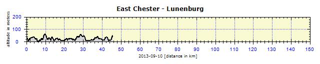
Lunenburg
Alain left me a note in the campsite to send him an e-mail about the next day's destination. His friends would drive him there. My cell phone only functioned sporadically in bigger cities. However, the campsite had WiFi which worked even from my tent.
The route to Hibernia campsite was easy. It was windless, cloudy yet warm and the road gently twisted across the agricultural landscape. I saw a car coming out of a shopping mall in Bridgewater with the front license plate: CZECH MATE. I stopped it and was rewarded by a conversation in Czech with many mistakes in a strong accent. The driver had picked up the language from his Czech wife. In the campsite, I managed to wash my clothes and then Alain arrived and the price for accommodation was again halved.
The next destination was near the Kejimkujik National Park, situated beside the lake of the same name. Road number 7 was not very busy, so I finally fulfilled an old promise to take some cycling photos. Alain was not very skilled at using my camera, he takes photos on his iPhone, so he had lost the photographic technique, if he ever had any. He probably did have it at one time – he told me that he had passed a course in digital photography and owned an expensive Canon G1X compact camera that he no longer used.
Kejimkujik National Park
I had to laugh when we were preparing our dinner back in the camp. I realized how funny we must look, two old codgers, who battled along by bike in the daytime, slept in tiny tents at night and cooked simple meals – mostly concerned about the quantity – and then with a satisfied expression, lit a fire. I said this to Alain who commented: "Yeah, life is great!" So that's how it was there.
Friday the 13th lived up its notoriety. A severe storm and rapid weather change were expected. The storm already struck during the night. We had our tents under the trees, but it rained so heavily that water started dripping on to my head through the air holes in the flysheet. This had never happened before. The strong rain prevented me from going out of the tent to close them, as I would have been immediately totally soaked and bring water back into the tent and sleeping bag. So I let it be – they were only drops, not pools that were forming. The rain mercifully stopped in the morning, giving us just enough time to pack up our wet tents and make breakfast. Then it started again. By the time that my sleeves were soaked, the rain had stopped and everything was dried by fast pedaling in the wind. I cycled to the historical Annapolis Royal, although it rained again even more than that morning. I only took one photo of the waterfront. Then I checked out the cozy Fort Anne from the outside, but I did not take my camera out in the cloudburst. It was a pity, the town has several really beautiful historical buildings and parks. The real adrenalin rush began when the local road number 1 connected to Highway 101. The side road was narrow, covered in almost 10 cm of deep water. There was at least 20 cm of water on a long bridge with heavy traffic, so the passing cars washed me from head to toe. In addition, there were thick rain clouds overhead. It was as dark as dusk. I switched the front and back lights on and was happy when I arrived safely in Digby.
We were lucky men, as the campsite had several roofs, under one of which I just fitted my tent. Alain had a slight problem, but finally also squeezed his tent under a shelter. After a whole day's cycling, the body becomes really damp, some of it coming from the outside, some of it produced by the body from the inside. It is like a Priessnitz compress on the whole body, so it must be healthy. There is only one disadvantage: usually one has trouble in the buttocks. Luckily I chased this away with Vaseline after a hot shower.
Goodbye, Nova Scotia
               |


")


