| Cycling east Canada and USA |  | |||||
 |
 |
 |
 |
 |
 |
 |
| Nothing compares to the simple pleasure of a bike ride. J.F.Kennedy | ||||||
| Statistics |
| Map of route |
| Miscellany |
| Profiles |
| Selected photos |
| E-mail the author |
| Writings from a trip |
| Québec |
| Newfoundland |
| Nova Scotia |
| New Brunswick |
| Maine |
| Massachusetts |
| New York |
| Washington D.C. |
| Virginia |
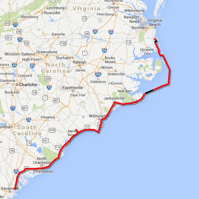
| < Carolinas > |
| Florida |
| Other trips |
| List of trips |
| Search |
| Four-month cycling trip, starting in late July 2013 in Quebec, ending in Orlando. Author's 10th expedition (New Zealand, Australia, USA, Canada, Alaska, Japan, Mexico, Bolivia, Chile, Argentina, Namibia, South Africa). |
|
North and South Carolina Knotts Island - ferry - Currituck, Jarvisburg, Point Harbour, Kitty Hawk (Bodie Island), Kill Devil Hills, Pea Island, Rodanthe (Hatteras Island), Buxton, Hatteras - ferry - Ocracoke Island, Ocracoke - ferry - Cedar Island, Stacy, Beaufort, Morehead City - Atlantic Beach (Bogue Island) - Emerald Isle - Ceadr Point - Jacksonville - North Topsail Beach (Topsail Island) - Surf City - Wilmington - Carolina Beach (Pleasure Island) - Fort Fisher - ferry - Southport - Supply - North Myrtle Beach (South Carolina) - Myrtle Beach - Hampton Plantation - McCleanville - Charleston - Magnolia Plantation - Colleton - Beaufort Upon crossing the border, I discovered that North Carolina is the State which favors the Army and soldiers. Paradoxically, when I crossed the border I was no longer disturbed by the noise of fighter planes, which had flown over my head the whole morning, practicing their skills. Totally flat, narrow road with no traffic, surrounded by water or rather swamps, on both sides. I had to take the ferry, which was free, from Knotts Island to Currituck. It took 45 minutes. I arrived at 12.30 p.m. and had an hour and a half to burn. So I fixed some small faults on my bike, oiled it and also played with a local Retriever, who was all excited to bring me some cones to throw for him.
About 15 km after Currituck, I passed a road sign for a campground 8 km away. I felt it was too early and wanted to continue a bit longer, ready to camp out in the wilds if necessary. After 5 p.m. I saw a scruffy motel, I only had one hour left before sunset, so I stopped there. It was only on the following day that I discovered what a good decision I had made. The roadside rest place 20 km away did seem quite comfortable, but it was located right on the outskirts of Kitty Hawk. It seemed as if I would have had to share the place with several homeless people. The worst part, however, was the crossing of a 2 km long bridge. Although there were two double-lane decks, one of them was closed due to construction, so the other one had to handle two-way traffic in two narrow lanes. The cars were OK, but when I saw a truck in the rear-view mirror, I had to stop and squeeze myself against the bridge rails so that it could pass safely. I could not imagine having to cross that bridge at dusk.
Outer Banks
Wright Brothers Memorial
However, take note! We, who know our stuff, know that this is not the full truth. The very first flight by a motorized plane was accomplished at least 10 years before the Wright brothers in a Siberian airplane, by Aeroplanovich Kridlenko Vrtulov. I am not 100% sure of the muzhik's name (literally: "Propellor Wing Aircraft Designer"), but the fact that a Russian was the first man to fly an aircraft can be verified in the book: About Russian Inventors of the XVIII and XIX published in the 50s. To your surprise, you will also discover that the Russians invented absolutely everything. The museum dedicated to the first flight also contains a gallery of paintings of important personages in aviation. The only non-American there is Yuri Gagarin, the first person in outer space. He increased the American shock at the launching of Sputnik and assisted in the enforcement of the J.F. Kennedy Space Program, which peaked with the landing on the Moon. Other distinctive people in the paintings are Mr. Cessna, the Rogallos couple and former American President George Bush Senior who was a military pilot. Apart from the memorial on the hill, from which the Wright brothers flew their gliders, a statue of a plane with life-sized figures is located below the hill. It depicts the start of the first flight. The flight was well documented in a famous photograph by John Daniels taken from a local rescue station. By the way, it was also the first photograph he ever took in his life. The Wright brothers then closed their bike store and started manufacturing planes which they also exported to Europe. A very typical American story. The next stop was Jockey's Ridge State Park, containing the biggest sand dunes on the island. The sand is very fine and gets into totally everything, so I only walked along a wooden walkway for a few hundred meters to look at the dunes. I did not try to climb them. The popular 300 m long Jennette's Pier can be seen in Nags Head, often sought out by fishermen even though one day of fishing there costs $12. It seems that it is worth it.
A cambered bridge, forcing me to change down to the lowest gear, took me to Pea Island and, at the same time, into a completely different world. While Bodie Island is populated and built up, Pea Island is a natural reserve with a total of three houses. The road is constantly covered by the sand blowing on to it from the nearby dunes and surrounded by sandy beaches and salt swamps. The island is a haven for birds, so it is forbidden to stay there overnight.
Hatteras Island
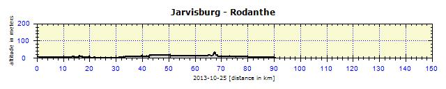
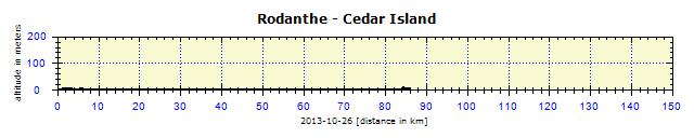
The second day was a carbon copy of the previous one. The wind from behind, flat road, tranquility. This was the second time in my life that my cyclocomputer had displayed on a 90 km long route, 'ascent 0' and "descent 0". Road like a spirit level (the first time this happened to me was in West Australia). Then the windless condition changed as the road turned in Buxton and the wind blew from 4 o'clock. But it was still just fine.
I detoured to see Cape Hatteras Lighthouse, the biggest lighthouse in North America, 208 ft. high. However, not even such a construction prevented the many shipwrecks. This is why this area is referred to as the "Cemetery of the Atlantic". I arrived at the first ferry, which transported me within 45 minutes, free of charge, to Ocracoke Island. In some parts, the island is so narrow, that there is only a beach the width of two traffic lanes next to the road. The island is home to many birds, but mainly to wild ponies. Nobody knows how they arrived there. They have their own assigned pasture land, where one can watch them from a distance.
After almost two hours on this 22-km long island, I decided to take the ferry to Cedar Island on that same day. The last ferry was at 4 p.m., this time costing $3. I was surprised by their thorough inspection, they even wanted to see the contents of some of my saddle-bags. After they saw the jumble in the first chosen one, they quickly changed their minds and waved me on to the ferry. The trip took 2 hours and 15 minutes, most of it spent talking to Mr. Butch over a cup of coffee. I had met him and his wife on a previous ferry. When we went ashore, it was rapidly getting dark. But a campsite was located right at the harbor, so I stayed there. I was alone in the tent zone. Only the female bathrooms were open – making them unisex – but I was the only one using them anyway. However, I was incredulous to discover that the toilet seats were soft in the female bathrooms, which I have never in my life seen in male bathrooms. I felt discriminated against.
When exiting the campground, I felt the atypical wind in my face and found it unpleasant. I had grown lazy and had got used to the aid of the wind and now suddenly I had to push against it. But it really was not dramatic. After the typical cambered bridge, I left Cedar Island and reached the continent. This, however, did not conclude my island travels – I planned to visit some more.
The city of Beaufort turned out to be a really nice stop. I turned into the center, located at the coast, and was delighted by the numerous well-preserved and maintained houses dating back to the time of the Civil War. Another cambered bridge, this time combined with liftable roadway, took me to Morehead City. The bridges are quite new here with emergency lanes of at least half a meter, so cycling over them is safe. I did not delay in Morehead and instead cycled over another causeway to find myself on another narrow, long island – the 34 km long Bogue Banks.
My Instincts did not Betray Me
I found the campground after searching for some time. There was a laundry with a coin-operated machine, which I was actually desperate for. The pitch was tiny, but grassy and level, so I was happy. The only problem was water, the faucet was about 200 meters away which complicated my cooking. First, I checked the laundry room, 400 meters away – open to 10 p.m. I cooked my dinner and headed to the laundry. While I washed and dried my clothes, I would work on my laptop at the fairly comfortable table. The laundry room was closed with a sign on the door: "Today open only till 8 p.m." I left it to the morning, I would get going a bit later. In the morning, I was at the laundry shortly after 8 a.m. – closed. So I walked to the office 600 meters away. No-one there, they opened at 9 a.m. Luckily, the owners also ran the gas station and local store, where I found a young girl and requested that they open the laundry. Then I marched back to the laundry. 15 minutes later, a car arrived and an apologetic lady unlocked the door. I got going at 10 a.m. but that was OK. At least, my tent had time to dry out. Even though it had not been raining, the high humidity and water had condensed on the inside.
What next? I was headed to the next island. A few years earlier, it had still been possible to cycle on Road 172 through an extensive military base and training grounds. This, however, was no longer possible. I had to ride around it, through Jacksonville. I took the turn-off to Road 17 and, without any warning whatsoever or signs forbidding cycling, I found myself on an expressway, a road of the highest grade, usually not permitting cyclists. I had no choice but to be on it for about 8 km, it was part of the city bypass. I was nervously expecting to hear a police siren behind me. I still do not know if I was allowed on that road or not. Only when I turned off on to a local road – direction Sneads Ferry – could I finally relax again. Then it was straight forward – a concave bridge over Alligator Bay and I reached Topsail Island. I no longer need to mention that it is a narrow, long island. You know this already.
In Surf City there was a pleasant looking campground. This was the family business of an elderly couple, who could not take care of everything, so it was not very well maintained. However, the basics functioned – water, electricity at my pitch, hot shower. And without hesitation, they offered me the price of $20 for the night, which is very unusual in that area.
The weather was great. One evening, four days earlier, I had been shivering from cold on Hatteras Island and considering whether to buy a sweater or a bottle of spirits the next day. However, it was sufficient to travel just slightly southwards and I was cycling in shorts and cycle clothes again, no leggings or jacket. No rain, most of the time sunny weather and the wind was not causing any problems either. Although it would sometimes be raining against me, it could not really be described as a storm. Finally, I bought neither sweater nor spirits.
Unanswered Doubts Again
I checked out the historical quarter of Wilmington, located on the Cape Fear River. The city is picturesque, a row of preserved historical buildings, masses of students from the local University which has a good reputation. Using a very busy road, I arrived at the campground in Carolina Beach. After four nights, this was the first time I was not sleeping on an island but on a peninsula. However, to leave it, I would have to take the ferry on the following day.
I crossed a bridge and was back on an island – Pleasure Island. Beautiful sandy beaches, the shore covered in grass. However, the environment was very commercial and touristy: stores, hotels, motels and restaurants. The nicest place on the island is Kure Beach with partly grassed beach and a long pier into the ocean. Next was the ferry to Southport, which departed every 45 minutes in the morning until 10 a.m., then it took a break. I wanted to see Fort Fisher, a Confederacy period fort, but it opened at 9 a.m. My ferry was to leave at 9.15 a.m. and I wanted to reach Myrtle Beach that same day, which was more than 100 km ahead of me. I prioritized the ferry.
For the 40-minute journey, I chatted away to a young lady who was commuting by ferry to work and dreamed of going on a cycle tour as well. The plan was not going so well – her husband disagreed with it, her son was still quite young, so she needed to discuss it at least with an old and weary wanderer. I gave her a card with my web address and hoped that she would be able to make her dreams come true.
Thereafter, it was quite boring, the local road led to Highway 17 with a narrow emergency lane and a high volume of traffic. I had to check the rear-view mirror frequently to react to potentially dangerous situations. Shortly after the border of South Carolina, there was an Information office, a precious source of information for me. I received a list of campsites, a map of Charleston and I could even have got the State road map, but I already had one. I entered the address of Myrtle Beach into the GPS. There was also a campsite in North Myrtle Beach, but I skipped that one.
I stopped, kicked out the bike stand and it fell off. You have no idea how such a silly problem can spoil a cycle trip. You want to take a photo and you have to either lean the bike against something or lie it down on the ground. So I welcomed the turn-off to Walmart, where I bought the only available and (what else in Walmart?) cheap stand. I knew that it would be bad quality, but it actually surpassed my skepticism. It lasted for three usages and then it curled up like an earthworm and I struggled to position it so that it would not obstruct me when pedaling. I passed several motels offering rooms for $40. I had a hunch that this might be the cheapest accommodation in the area. When I reached the campground, the price for a tent pitch was $50 plus tax. The following campground, 2 km further on, decreased the price to $45 for a pitch far from the beach. Both campsites were not my style – focusing their business on massive RVs, a camping factory disrespectful of campers in tents. No privacy, pitches on top of each other, far from water, showers and bathrooms. I had already covered 110 km, but I decided to give them a miss. The campground in Myrtle Beach State Park was 22 km further on, but I knew I could make it before dusk. And I was right, although delayed by traffic lights, I arrived by 5.30 p.m. and it was the kind of camp I like. Hidden in a forest, adjacent to the beach, large pitches under the trees, clean bathrooms and showers. I gave them my name and they displayed my information from the previous nights spent in State campgrounds. Price $32, great considering the area.
The WiFi reached all the way to my tent, so I could book a cheap motel for two nights in Charleston, to arrive two days later. The motel was 10 km from the city center, but accommodation in the center would be at least three times more expensive. I caught up with a cyclist from New York, who also aimed to reach Florida and after that to cycle to Chicago (would he not get frostbite in Chicago in December?) and then back to NY. This was his way of dealing with his job problems – he had been fired and needed to consider what to do next. We parted company in Georgetown. I went to see the historical part of the city, which he claimed was not worth seeing. He was right.
The cycle track across the Francis Marion National Forest looked very impressive on the State map. There were even two campsites along the way. But first I had a look at Hampton Plantation State Historic Site, a rice plantation of one of the signatories of the Declaration of Independence. It was rather stressful, as I had to push the bike for about 2 km along a deep sandy track. Ideal place for sleeping over – bathrooms with running water, tables, nobody around. But the place was locked up at 5 p.m.. If I came across a Ranger, I would try to ask him if I could sleep over there. Instead, I only viewed the building from the outside and pushed my bike through the sand back to the road.
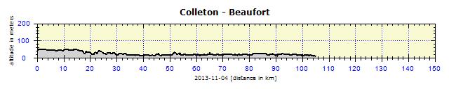
It took me about 10 km of cycling to find the cycle path marked on the map. Then I figured that it must be the Old Georgetown Road, a dust road with sand drifts. I did not go that way, but returned to Highway 17 and sought out accommodation in McCleanville. With no success. It was 5.30 p.m., one hour before dusk. So I cycled into a forest and found a small spot to pitch my tent, which was highly welcomed by the local insects, who tried to eat me for all their worth. I used up the remains of my repellent and saved myself from total devastation. I cleaned my sweaty body with cleaning tissues and gratefully drank one beer. I did not cook any dinner. I did not want to risk burning everything down in that dry season. The air was stuffy and hot. I just rolled from side to side in the tent. I had to open the sides, which luckily have insect nets, otherwise I would not have been able to sleep. I set off hungry, against a strong wind and it took a whole 35 km till I had the opportunity to have breakfast. This is very unusual, usually one finds at least a gas station with a store along the road – but there, nothing. The road stretched through an extensive State forest and bypassed two small villages that might have had a store in their centers. I approached Charleston on Road 17 and stopped at a red traffic light before a bridge. The driver next to me told me that cyclists were not allowed on the bridge, but there was a bypass somewhere on the left. I took out my GPS and entered a request for a cycle route to Charleston, which then took me on to a separate cycle and pedestrian lane. Crossing the 4 km long bridge was a tourist attraction, so I encountered many pedestrians and even one cyclist. If you look at the altitude map, the tiny mount is the bridge, everything else is as flat as a pancake.
I rode through the historical part of Charleston but, due to the missing stand on my bike, did not photograph anything. It is awkward to lie a bike down on a busy path, or lean it against something and then worry about it hurting someone if it falls down. I connected my sightseeing with searching for a bike store. I found two. The first one offered a stand of about the same quality as the one from Walmart, the second store had a stronger one of solid aluminum, but its height could not be adjusted. They said not to worry. They attached the stand to my bike and then shortened it with massive lever pliers. All this for about $10. My right pedal had started to scrape, so I was also looking for new SPD pedals. They only had one-sided ones for $100, so mine would have to last for a bit longer. I oiled them thoroughly instead. It was nearly evening, so I cycled over another bridge on a pedestrian path and reached the motel 10 km away. I had to carry all my things and the bike up one floor, as my specially discounted Internet price was not for a ground-floor room into which I could simply have pushed the bike.
Charleston
The bus ticket cost $1.75 and half an hour later I was in Charleston center. The center is served by old buses on three sightseeing routes downtown that are, consider this, free of charge. Here you see the 'greed of capitalists'. And I certainly used their service later to rest my tired legs which seemed to have forgotten how to walk. However, first I visited the farmers' market on Marion Square – a lively place with music and dancers spinning around on their heads. Everyone was eating or drinking something and, in all this chaos, dogs and kids were running around. A Saturday as it should be.
Then I wandered around for several hours in Charleston and was happy to be on foot. I had also enjoyed the bike ride the previous day, but I'd had no time to enjoy the details which one sees when walking slowly and attentively observing the surroundings. Hard to describe, it needs to be experienced. I absorbed the Southern atmosphere and amplified it with lunch – grilled pork ribs and a glass of red wine. The day was a success and the only duty left was to take care of all my sweaty clothes. The motel had a laundry, so in ninety minutes and for a few quarters, I washed and dried my clothes.
Magnolia Plantation
Manpower is expensive today, rice prices fluctuate. But smart plantation owners have started to grow tourism, instead of rice. This is also the case of Magnolia. Well positioned, 20 km from Charleston center, but with two great plantations competing in the vicinity – all three situated on Highway 61 on the Ashley River. It is hard to choose among them. Magnolia offers a $5 entry discount on a coupon from the free map of the historical Charleston center. So the day before, I enjoyed a beer for a fiver in a pub and the day after headed to Magnolia. You know it – I wouldn't want a free discount.
The plantation opens at 8.30 a.m., so I got up early to have enough time for viewing and also to reach my chosen campground. I arrived at 9 o'clock. Closed. Banging on the gates did not help either. I could not figure out how it was possible. Then I turned on the GPS which displayed the time as 8.00. The time had changed again. It was the Fall Saturday/Sunday shift to winter time. This really should be abandoned and it should be pointed out that time change was introduced (at least in the Czech Republic) by a guy called Adolf Hitler (together with the change to driving on the right). I believe that summer time no longer has any economic value, and is used only out of the inertia and laziness of politicians.
Visiting a plantation is not a cheap event. The entry fee is either basic – gardens, green labyrinth, mini zoo. For an extra charge, a total of $47 with discount, one can take a trip on a mini-train, boat (I did that - I wanted to see alligators), viewing of the building, an exhibition on the slave trade and its abolition, viewing of slave houses and a garden in the swamp. The ticket can be used for a second entry within a week for the purchased area. I was their first visitor, but not for long – by the time I was leaving at 1 p.m., the plantation was filled with people. It was Sunday, ideal for a family outing with children. The day passes very quickly there. I left the children at home, so I had seen everything after four hours. But my grandchildren would have found it very exciting, especially the zoo where they could chase the hens, peacocks, turkeys, geese, goats, deer and ponies. I, on the other hand, was excited about 'chasing' alligators on the cruise through the rice fields, in which small islands of reeds, moved by the fresh wind, also floated.
Road 61 was a cyclist's heaven. A gently twisting road, so that one would not get lazy and had to change gears from time to time, leading through a tunnel of ancient trees, protecting the road from the hammering headwind. No trucks on Sundays and I increased my security by a blinking red light on my helmet, which helped to make me visible in the dark parts.
Law and Order
Eternal Problem with Speed Sensor The third problem was the speed measuring sensor, without which the cyclocomputer could not measure the distance traveled. The sensor is wireless, encoded, and without changeable batteries – the whole sensor always needs to be replaced. I always carry a spare. The first one stopped working on Newfoundland. I changed it and it worked for a few weeks. In Nova Scotia, the second one started having problems, it started functioning only after a few kilometers, or not at all. So I kept adjusting it, finding a better position till it worked again. This usually took me half an hour, often standing somewhere in an emergency lane. Finally it stopped working completely. Luckily, the first one started functioning again. I opened the dead sensor with a knife, found out what batteries it used and bought them. I tried getting the opened one to function with new batteries, but no luck. I could not get hold of a new one anywhere. Polar was not sold in the USA and, if it was, they only sold old models without the coded transfer. It became clear that it was only a question of time before I had no sensor. When that happened, I would have to cycle with the GPS on to find the cycled distance. The last few mornings had been getting colder and, when leaving the Colleton campground, the sensor was dead. I waited for a few kilometers, still nothing. I tried adjusting its position, still no go. While the sensor did connect to the computer, it did not have enough energy left to transfer the impulses from the rotating wheel. I hesitated, but then decided to try the only available option. I cracked the sensor to open it with a knife and then changed the battery. To prevent water penetrating the interior, I sealed it with silver tape and thus far it had been working like a charm. I just didn't know what the first real rain would do to it.
Beaufort was the last city on my route through South Carolina. Although it was highly praised in the free tourist guide as a historical city, I saw it differently. I might as well have skipped it and headed directly to Savannah. I personally took a greater interest in the hydroplanes, taking off and landing at a nearby base, so I had something to look at while cycling. Beaufort was the last city on my route through South Carolina. Although it was highly praised in the free tourist guide as a historical city, I saw it differently. I might as well have skipped it and headed directly to Savannah. I personally took a greater interest in the hydroplanes, taking off and landing at a nearby base, so I had something to look at while cycling.
           |